 atlanta.urbanize.city
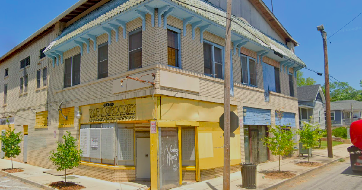
Westside's cherished 'the Yellow Store' set for mixed-use rehab Josh Green Mon, 10/21/2024 - 08:08 New life is on the horizon for a century-old structure that served as a communal hub for decades during English Avenue’s heyday. Colloquially known as “the Yellow Store,” the two-story Westside structure at 500 James P. Brawley Drive will be preserved and renovated in a way that echoes its original uses, with “neighborhood retail” at street level and residences above, according to project leaders with Invest Atlanta, the city’s economic development arm. The Invest Atlanta Board of Directors recently approved a $750,000 Westside Tax Allocation District grant for the English Avenue project as part of a round of funding for initiatives that aim to lift up lower-income neighborhoods. [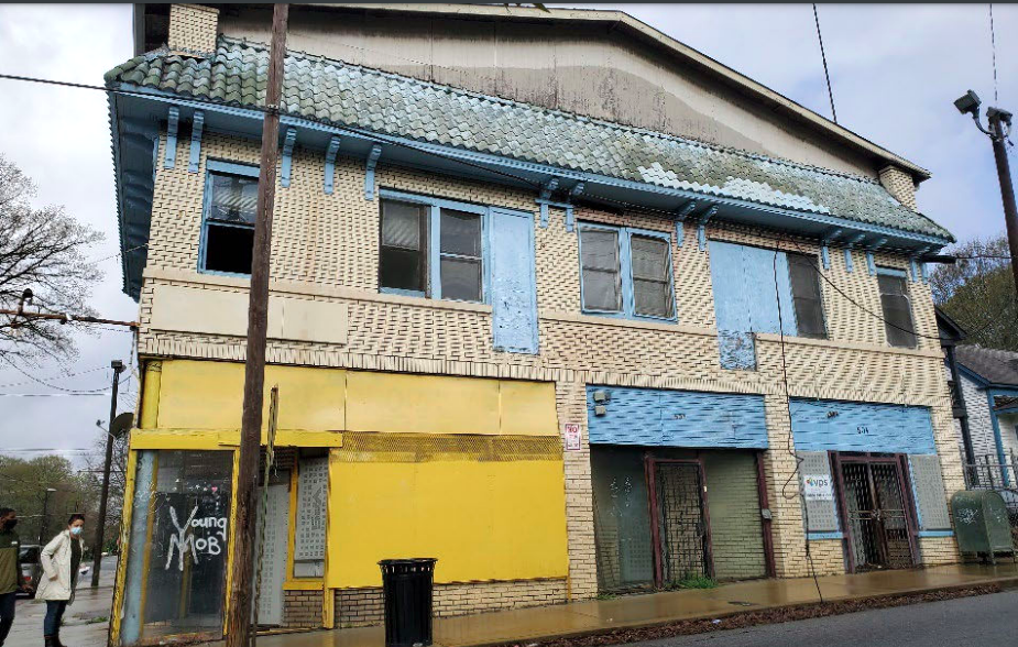](https://atlanta.urbanize.city/sites/default/files/styles/1140w/public/2024-10/500%20James%20P%20Brawley%20Drive%20The%20Yellow%20Store%202.png?itok=ti6q8oHW "Westside Future Fund") The front of the brick structure, facing east toward downtown. Westside Future Fund [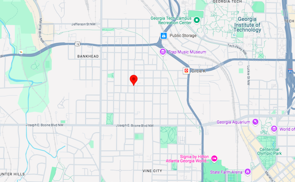](https://atlanta.urbanize.city/sites/default/files/styles/1140w/public/2024-10/500%20James%20P%20Brawley%20Drive%20The%20Yellow%20Store%201.png?itok=EM2eae5O "Google Maps ") The building's 500 James P Brawley Drive location in English Avenue. Google Maps Additions to the building will include an outdoor canopy behind it where seating will be placed for a local food service tenant. No timeline for construction was included in the project announcement. Five years ago, local nonprofit Westside Future Fund purchased the building for $600,000 from longtime family owners to eventually redevelop it into a communal gathering place with housing. According to [Saporta Report](https://saportareport.com/westside-future-fund-buys-key-yellow-store-property/sections/reports/maria_saporta/), the corner building had housed a soda shop and ice cream parlor, a shoe store, a grocery, and a record store downstairs, with four apartments above. Its renovation was pinpointed as a top neighborhood priority in the Westside Land Use Framework Plan. [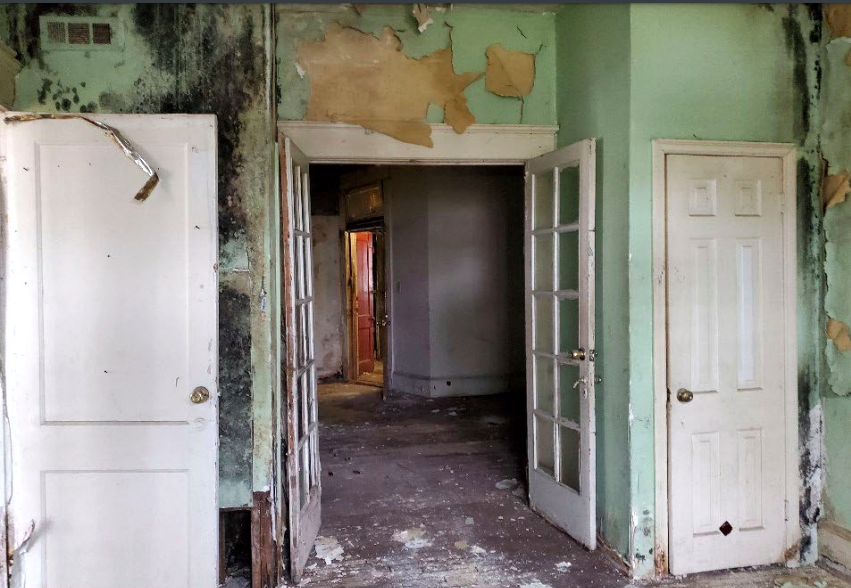](https://atlanta.urbanize.city/sites/default/files/styles/1140w/public/2024-10/500%20James%20P%20Brawley%20Drive%20The%20Yellow%20Store%20apartment%20.png?itok=A17CgiRK "Westside Future Fund") Inside a typical upstairs unit today. Westside Future Fund [](https://atlanta.urbanize.city/sites/default/files/styles/1140w/public/2024-10/500%20James%20P%20Brawley%20Drive%20The%20Yellow%20Store%204.png?itok=kT34f1PI "Westside Future Fund") Westside Future Fund According to Westside Future Fund, the two-story building appears in the 1911 Sanborn Map for that section of Atlanta, and its size of 6,000 square feet listed on the original permit remains unchanged. It was built of blonde multi-wythe brick masonry, per the organization. Today, the location is about four blocks west of the Westside Beltline Connector trail that links downtown Atlanta to the mainline Beltline loop. [](https://atlanta.urbanize.city/sites/default/files/styles/1140w/public/2024-10/500%20James%20P%20Brawley%20Drive%20The%20Yellow%20Store%20commercial.png?itok=VFE-o5TT "Westside Future Fund") Current state of commercial spaces. Westside Future Fund [](https://atlanta.urbanize.city/sites/default/files/styles/1140w/public/2024-10/500%20James%20P%20Brawley%20Drive%20The%20Yellow%20Store%203.png?itok=vQwQ2tLO "Westside Future Fund") Westside Future Fund **...** ***Follow us on social media:*** [Twitter](https://twitter.com/UrbanizeATL) / [Facebook](https://www.facebook.com/UrbanizeATL)/**and now:** [Instagram](https://www.instagram.com/urbanizeatlanta_/) • [English Avenue news, discussion](https://atlanta.urbanize.city/neighborhood/english-avenue) (Urbanize Atlanta) Tags [500 James P Brawley Drive NW](https://atlanta.urbanize.city/tags/500-james-p-brawley-drive-nw) [The Yellow Store](https://atlanta.urbanize.city/tags/yellow-store) [Invest Atlanta](https://atlanta.urbanize.city/tags/invest-atlanta) [Invest Atlanta Board](https://atlanta.urbanize.city/tags/invest-atlanta-board) [Westside](https://atlanta.urbanize.city/tags/westside-0) [Westside BeltLine Connector](https://atlanta.urbanize.city/tags/westside-beltline-connector) [Goodr Be On Edgewood](https://atlanta.urbanize.city/tags/goodr-be-edgewood) [City of Refuge](https://atlanta.urbanize.city/tags/city-refuge) [Adaptive Reuse](https://atlanta.urbanize.city/tags/adaptive-reuse-4) [Adaptive-Reuse](https://atlanta.urbanize.city/tags/adaptive-reuse-0) [Adaptive-Reuse Development](https://atlanta.urbanize.city/tags/adaptive-reuse-development) [Atlanta Mixed-Use](https://atlanta.urbanize.city/tags/atlanta-mixed-use) [Mixed-Use Development](https://atlanta.urbanize.city/tags/mixed-use-development) [Westside Future Fund](https://atlanta.urbanize.city/tags/westside-future-fund) [Westside Land Use Framework Plan](https://atlanta.urbanize.city/tags/westside-land-use-framework-plan) Images [](https://atlanta.urbanize.city/sites/default/files/styles/1140w/public/2024-10/500%20James%20P%20Brawley%20Drive%20The%20Yellow%20Store%201.png?itok=EM2eae5O "Google Maps ") The building's 500 James P Brawley Drive location in English Avenue. Google Maps [](https://atlanta.urbanize.city/sites/default/files/styles/1140w/public/2024-10/500%20James%20P%20Brawley%20Drive%20The%20Yellow%20Store%20lead.png?itok=BKdrPZ3L "Google Maps ") The two-story structure in June this year. Google Maps [](https://atlanta.urbanize.city/sites/default/files/styles/1140w/public/2024-10/500%20James%20P%20Brawley%20Drive%20The%20Yellow%20Store%20commercial.png?itok=VFE-o5TT "Westside Future Fund") Current state of commercial spaces. Westside Future Fund [](https://atlanta.urbanize.city/sites/default/files/styles/1140w/public/2024-10/500%20James%20P%20Brawley%20Drive%20The%20Yellow%20Store%20apartment%20.png?itok=A17CgiRK "Westside Future Fund") Inside a typical upstairs unit today. Westside Future Fund [](https://atlanta.urbanize.city/sites/default/files/styles/1140w/public/2024-10/500%20James%20P%20Brawley%20Drive%20The%20Yellow%20Store%202.png?itok=ti6q8oHW "Westside Future Fund") The front of the brick structure, facing east toward downtown. Westside Future Fund [](https://atlanta.urbanize.city/sites/default/files/styles/1140w/public/2024-10/500%20James%20P%20Brawley%20Drive%20The%20Yellow%20Store%203.png?itok=vQwQ2tLO "Westside Future Fund") Westside Future Fund [](https://atlanta.urbanize.city/sites/default/files/styles/1140w/public/2024-10/500%20James%20P%20Brawley%20Drive%20The%20Yellow%20Store%204.png?itok=kT34f1PI "Westside Future Fund") Westside Future Fund Subtitle Vacant, century-old structure to blend retail, residential following grant Neighborhood [English Avenue](https://atlanta.urbanize.city/neighborhood/english-avenue) Background Image Image 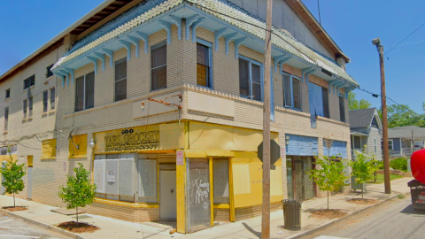 Before/After Images Sponsored Post Off
 atlanta.urbanize.city
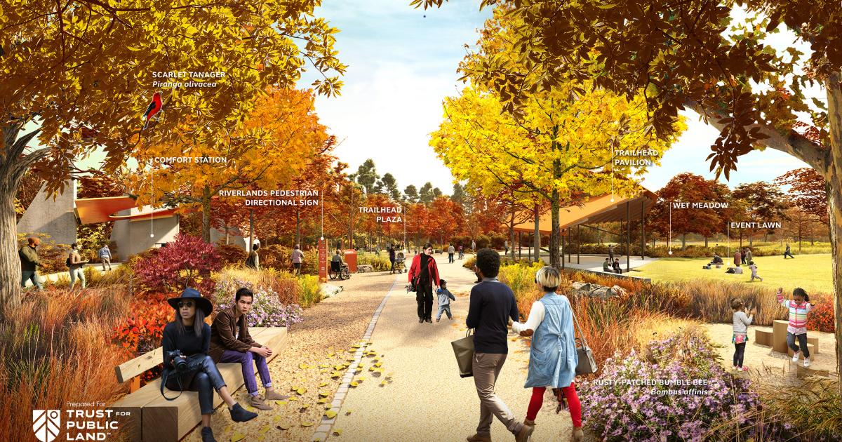
Blank Family donation to help link Atlanta to Chattahoochee River Josh Green Thu, 10/17/2024 - 13:58 A donation from Atlanta Falcons and United owner Arthur Blank’s foundation will help bring to fruition better access points to what’s generally considered an underappreciated resource: the Chattahoochee River. Trust for Public Land officials announced this week the Arthur M. Blank Family Foundation has contributed $2.5 million to the ambitious [Chattahoochee RiverLands](https://www.chattahoocheeriverlands.com/) project, a planned 100-mile linear park that would link 20 cities and seven counties along the river through metro Atlanta. The Blank foundation’s contribution brings fundraising tallies for the RiverLands initiative to north of $49 million—with more than $22 million of that sourced from private donations, and the rest from public funding coffers. According to TPL officials, the RiverLands recreation destination—billed as “metro Atlanta’s ultimate outdoor experience”—will eventually stretch 100 miles from Buford Dam down to Chattahoochee Bend State Park in Newnan. In between will be trails, parks, and amenities that connect nearly 1 million residents nearby to outdoor options such as kayaking, hiking, cycling, swimming, and camping, according to TPL. But first things first. The initial RiverLands projects, both under construction now, will serve as smaller-scale examples of how the broader riverside concept could look and function. Blank’s contribution is “essential” to closing out needed funding for one of those projects, the [Camp + Paddle Trail](https://atlanta.urbanize.city/post/atl-first-chattahoochee-river-public-access-point-underway), George Dusenbury, TPL’s Georgia state director, tells Urbanize Atlanta. The Camp + Paddle Trail, which broke ground in November, will span 48 miles and provide visitors a three-night, four-day itinerary for exploring the river with three campsites, restrooms, pavilions, and other amenities included. It will start at Peachtree Creek in north Atlanta and wiggle down to a 1,400-acre greenspace called McIntosh Reserve in Carroll County, marking the southern end of the RiverLands. The trail will also include a kayak launch at Atlanta’s [Standing Peachtree Greenspace](https://www.buckhead.com/who-cares-about-standing-peachtree/), a historical site in Buckhead. [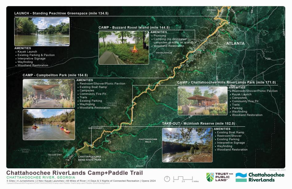](https://atlanta.urbanize.city/sites/default/files/styles/1140w/public/2023-11/Chattahoochee%20RiverLands%20Camp-and-Paddle-Trail_MAP%20%281%29.jpg?itok=ChZgB5D5 "Courtesy of TPL") Scope of the five sites considered destinations along the Camp+Paddle Trail between North Atlanta (top) and Carroll County. Courtesy of TPL Dusenbery said construction on the Camp + Paddle Trail and its amenities is scheduled to finish in the next few months, and that planning for ribbon-cuttings is underway. The second initial project has its purpose baked into its name. The Cobb County Showcase site—a 2.7-mile greenway and trail—will connect Mableton up to Smyrna along the Chattahoochee’s banks. Dusenbery predicts the showcase project will demonstrate the RiverLands’ functionality and impact in a way that’s similar to how Ponce City Market and Historic Fourth Ward Park showed Atlantans what’s possible with Beltline redevelopment. [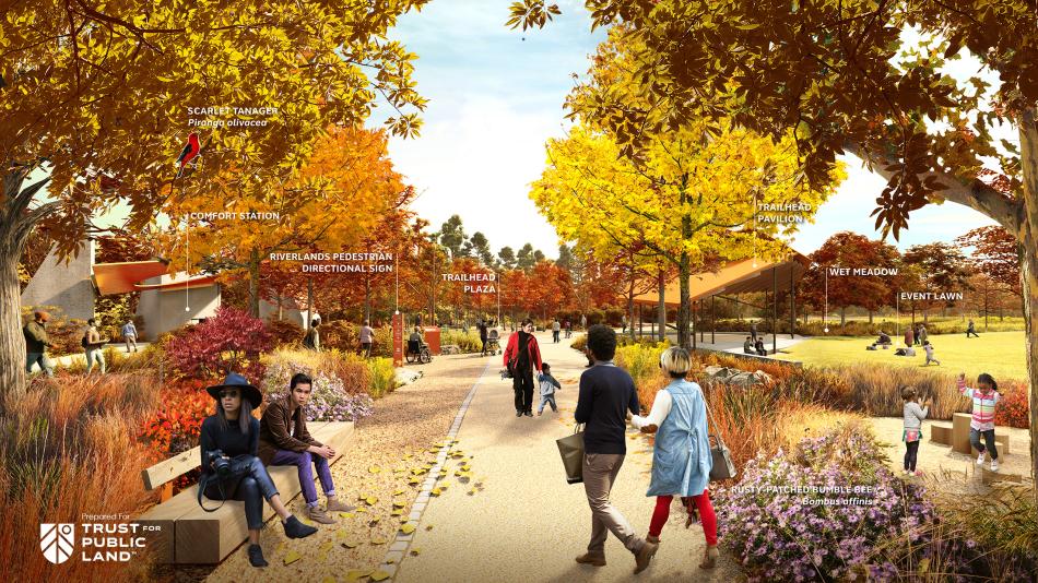](https://atlanta.urbanize.city/sites/default/files/styles/1140w/public/2024-03/Chattahoochee%20RiverLands%20Gateway%20Park%20.jpg?itok=GPG_MN5N "Courtesy of Trust for Public Land ") Future plans for RiverLands Gateway Park in Cobb County. Courtesy of Trust for Public Land Highlights will include a new 12-acre greenspace—RiverLands Gateway Park in Mableton, a former industrial site near Six Flags Over Georgia—along with three river access points, ecological restoration, and improved amenities at two existing parks, among other upgrades. RiverLands Gateway Park will also connect to the Mableton Parkway Trail, providing a vital trail link between the Chattahoochee RiverLands project and Silver Comet Trail. [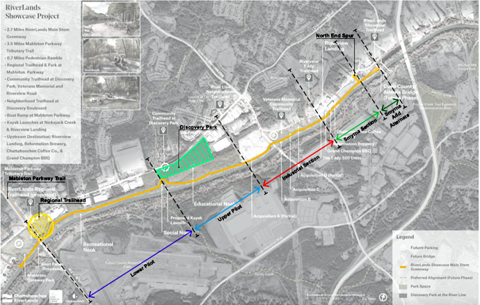](https://atlanta.urbanize.city/sites/default/files/styles/1140w/public/2024-10/Chattahoochee%20RiverLands%20Showcase_PhasingDiagram.png?itok=UKqXNvyx "Trust for Public Land ") Planned phasing for the Chattahoochee RiverLands showcase project in Cobb County. Trust for Public Land Dusenbery told Urbanize the Cobb County Showcase project is expected to finish sometime in 2026. But a TPL ribbon-cutting for the first section of finished trail could come in December alongside Cobb County officials, Dusenbery said. In the donation announcement, Fay Twersky, Arthur M. Blank Family Foundation president, said access to the Chattahoochee River “will bring metro Atlanta another connection to the outdoors, which is vitally important to our community’s overall well-being.” **...** ***Follow us on social media:*** [Twitter](https://twitter.com/UrbanizeATL) / [Facebook](https://www.facebook.com/UrbanizeATL)/**and now:** [Instagram](https://www.instagram.com/urbanizeatlanta_/) • [Cobb County news, discussion](https://atlanta.urbanize.city/neighborhood/cobb-county) (Urbanize Atlanta) Tags [Chattahoochee River](https://atlanta.urbanize.city/tags/chattahoochee-river) [RiverLands Gateway Park](https://atlanta.urbanize.city/tags/riverlands-gateway-park) [Chattahoochee River Lands](https://atlanta.urbanize.city/tags/chattahoochee-river-lands) [Chattahoochee RiverLands](https://atlanta.urbanize.city/tags/chattahoochee-riverlands) [Trust for Public Land](https://atlanta.urbanize.city/tags/trust-public-land-0) [Atlanta Parks](https://atlanta.urbanize.city/tags/atlanta-parks) [Smyrna](https://atlanta.urbanize.city/tags/smyrna) [Cobb County](https://atlanta.urbanize.city/tags/cobb-county) [Atlanta River](https://atlanta.urbanize.city/tags/atlanta-river) [Interstate 285](https://atlanta.urbanize.city/tags/interstate-285) [Mableton](https://atlanta.urbanize.city/tags/mableton) [Riverview Landing](https://atlanta.urbanize.city/tags/riverview-landing) [State of Georgia](https://atlanta.urbanize.city/tags/state-georgia) [Georgia Outdoor Stewardship Program](https://atlanta.urbanize.city/tags/georgia-outdoor-stewardship-program) [Georgia Department of Natural Resources](https://atlanta.urbanize.city/tags/georgia-department-natural-resources) [Arthur Blank](https://atlanta.urbanize.city/tags/arthur-blank) [Arthur M. Blank Family Foundation](https://atlanta.urbanize.city/tags/arthur-m-blank-family-foundation-0) [Cobb County Showcase](https://atlanta.urbanize.city/tags/cobb-county-showcase) [McIntosh Reserve](https://atlanta.urbanize.city/tags/mcintosh-reserve) [Camp+Paddle Trail](https://atlanta.urbanize.city/tags/camppaddle-trail) [Standing Peachtree Greenspace](https://atlanta.urbanize.city/tags/standing-peachtree-greenspace) Images [](https://atlanta.urbanize.city/sites/default/files/styles/1140w/public/2024-10/Chattahoochee%20RiverLands%20Showcase_PhasingDiagram.png?itok=UKqXNvyx "Trust for Public Land ") Planned phasing for the Chattahoochee RiverLands showcase project in Cobb County. Trust for Public Land [](https://atlanta.urbanize.city/sites/default/files/styles/1140w/public/2024-03/Chattahoochee%20RiverLands%20Gateway%20Park%20.jpg?itok=GPG_MN5N "Courtesy of Trust for Public Land ") Future plans for RiverLands Gateway Park in Cobb County. Courtesy of Trust for Public Land [](https://atlanta.urbanize.city/sites/default/files/styles/1140w/public/2023-11/Chattahoochee%20RiverLands%20Camp-and-Paddle-Trail_MAP%20%281%29.jpg?itok=ChZgB5D5 "Courtesy of TPL") Scope of the five sites considered destinations along the Camp+Paddle Trail between North Atlanta (top) and Carroll County. Courtesy of TPL [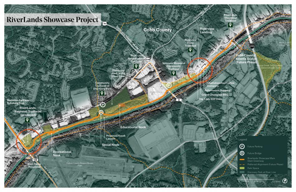](https://atlanta.urbanize.city/sites/default/files/styles/1140w/public/2023-03/Chattahoochee%20Riverlands_Showcase_Project_3.8.2023.jpg?itok=gcD984mW "Courtesy of Trust for Public Land") The initial RiverLands trailhead site, at left, with I-285 pictured at right. Courtesy of Trust for Public Land Subtitle Officials: Funding key in first under-construction projects for Chattahoochee RiverLands vision Neighborhood [Cobb County](https://atlanta.urbanize.city/neighborhood/cobb-county) Background Image Image  Before/After Images Sponsored Post Off
 atlanta.urbanize.city
Study: Atlanta ranks measly 14th in U.S. for development since 1980 Josh Green Wed, 10/16/2024 - 12:20 Anyone who’s considered “Atlanta, Georgia” synonymous with “Sunbelt boomtown” in recent decades might find the results of a new national, urban development analysis surprising. At least on the surface. A team of analysts with StorageCafe, an online platform with nationwide storage unit listings, studied [44 years’ worth of real estate development data](https://www.storagecafe.com/blog/top-cities-for-real-estate-development-in-the-us-over-the-last-half-century/), dating back more than four decades, that shows Atlanta ranked 14th nationally when all categories are combined. The rankings were based on building permit numbers pertaining to office, retail, multifamily, single-family, industrial, and self-storage development between 1980 and December 2023. The largest 100 cities in the U.S. with populations of more than 200,000 were analyzed. “Atlanta’s sheer amount of new commercial, industrial, and multifamily construction has vaulted [it] into the ranks of real estate powerhouses like Dallas, Austin, and Miami,” StorageCafe reps noted in an email to Urbanize Atlanta. But still—*14th place*? In a city that’s been [transformed](https://atlanta.urbanize.city/post/30-years-later-remembering-legendary-atlanta-megaproject-fell-apart) (by a population that’s tripled) since the early 1990s, let alone 1980? [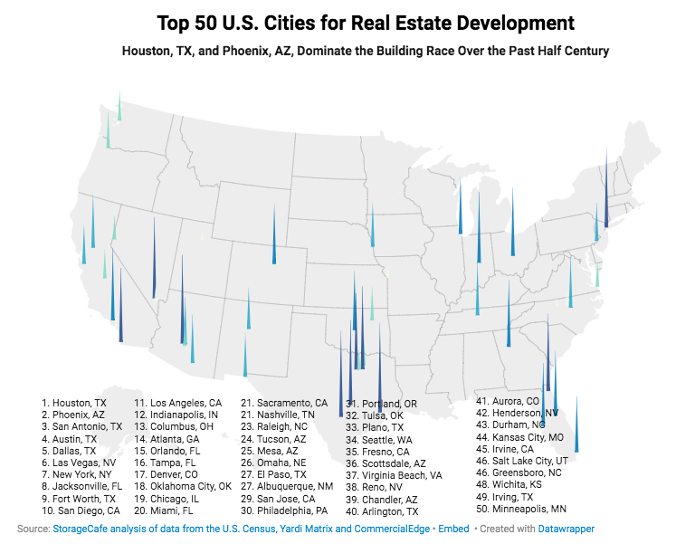](https://atlanta.urbanize.city/sites/default/files/styles/1140w/public/2024-10/StorageCafe%20U.S.%20Development%20study%202.png?itok=pXnmvuRh "STORAGECafé") STORAGECafé It’s important to note the City of Atlanta—a relative sliver of land mass, with a [growing](https://atlanta.urbanize.city/post/metro-atl-population-63k-more-people-report-past-year) but still meager population of roughly 532,000—was studied in this case, and not the broader metro. (The City of Phoenix, for instance, has an [estimated](https://www.census.gov/quickfacts/fact/table/phoenixcityarizona/PST045223) population of 1.6 million—more than three times larger than the City of Atlanta’s, but in a significantly smaller metro area. And metro Dallas’ Fort Worth ranked No. 9 overall in the StorageCafe study—apart from neighboring Dallas at No. 5.) Still, the City of Atlanta managed to hold its own in the rankings. One highlight was more than 108 million square feet of office space delivered in the city since 1980—good for third position nationally in that sector, per the study. Atlanta’s 139,000 multifamily units that have cropped up in the past five decades—11th most nationwide—have “dramatically reshaped [the city’s] skyline,” analysts noted. The 2000s were Atlanta’s peak decade for the multifamily boom, with more than 5,700 permits issued on average per year. That pace slowed to about 3,660 permits annually in the 2010s. But following the pandemic, multifamily development has bounced back, with the annual average this decade now north of 4,850 permits. For better or worse, single-family construction has been a different story since 1980. The City of Atlanta has issued just 29,000 standalone home permits in that timespan. (Compare that with 215,000 permits in Phoenix, the top city in that sector, or No. 2 Houston’s 166,200 homes.) [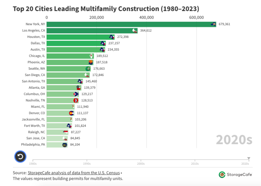](https://atlanta.urbanize.city/sites/default/files/styles/1140w/public/2024-10/StorageCafe%20U.S.%20Development%20study%201.png?itok=suHlXC_7 "STORAGECafé") STORAGECafé New retail space—grappling with an era of e-commerce and shifting consumer habits—has been another low point. Atlanta ranks 16th nationally for new retail space since 1980, but its annual average of 291,000 square feet delivered in the 2020s marks a 45 percent decrease from the teens and a five-decade low, according to the study. Big picture, analysts found that Southern and Southwestern cities dominated the growth rankings, snatching 15 of the country’s top 20 slots, with Atlanta included. “As one of the Sunbelt’s biggest boomtowns,” StorageCafe reps wrote, “Atlanta’s housing market has been buoyed by strong demand, but new development still struggles to keep pace with rapid population and job growth.” [](https://atlanta.urbanize.city/sites/default/files/styles/1140w/public/2024-02/lead%20Midtown%20Alliance%202023%20recap.png?itok=rD24_kyz "Midtown Alliance/2023 Progress Report ") Midtown Alliance/2023 Progress Report **...** ***Follow us on social media:*** [Twitter](https://twitter.com/UrbanizeATL) / [Facebook](https://www.facebook.com/UrbanizeATL)/**and now:** [Instagram](https://www.instagram.com/urbanizeatlanta_/) • [Atlanta declared No. 2 most livable city in U.S. for 2024](https://atlanta.urbanize.city/post/atl-declared-no-2-most-livable-city-us-2024) (Urbanize Atlanta) Tags [STORAGECafé](https://atlanta.urbanize.city/tags/storagecafe) [Atlanta Population](https://atlanta.urbanize.city/tags/atlanta-population) [Atlanta Population Growth](https://atlanta.urbanize.city/tags/atlanta-population-growth) [Atlanta Growth](https://atlanta.urbanize.city/tags/atlanta-growth) [Atlanta Development](https://atlanta.urbanize.city/tags/atlanta-development) [Atlanta Construction](https://atlanta.urbanize.city/tags/atlanta-construction) [Atlanta Office Space](https://atlanta.urbanize.city/tags/atlanta-office-space) [Office Space](https://atlanta.urbanize.city/tags/office-space-0) [Atlanta Multifamily](https://atlanta.urbanize.city/tags/atlanta-multifamily) [Single-Family Homes](https://atlanta.urbanize.city/tags/single-family-homes) [Atlanta Studies](https://atlanta.urbanize.city/tags/atlanta-studies) [Market Studies](https://atlanta.urbanize.city/tags/market-studies) Images [](https://atlanta.urbanize.city/sites/default/files/styles/1140w/public/2024-10/StorageCafe%20U.S.%20Development%20study%201.png?itok=suHlXC_7 "STORAGECafé") STORAGECafé [](https://atlanta.urbanize.city/sites/default/files/styles/1140w/public/2024-10/StorageCafe%20U.S.%20Development%20study%202.png?itok=pXnmvuRh "STORAGECafé") STORAGECafé Subtitle Huh? Neighborhood [Citywide](https://atlanta.urbanize.city/neighborhood/citywide) Background Image Image  Before/After Images Sponsored Post Off
 atlanta.urbanize.city
Vision emerges for final building at Glenwood Park neighborhood Josh Green Mon, 10/14/2024 - 10:40 More than 20 years after construction began on drab, former industrial land next to Interstate 20, the final piece of celebrated New Urbanism neighborhood Glenwood Park is coming into focus. The last available lot at the Ormewood Park project will see a four-story, mixed-use office building take shape with a throwback design and scale that recalls Atlanta architecture from a century ago in places such as Broad Street downtown. That’s according to a [thoughtful report](https://www.cnu.org/publicsquare/2024/10/02/wrapping-landmark-new-urban-neighborhood) this month from Congress for the New Urbanism titled “Wrapping up a landmark new urban neighborhood” that chronicles Glenwood Park’s transition from a 28-acre, abandoned concrete recycling plant to an organically walkable neighborhood beginning in 2003. The final development site in question is a grassy corner at 415 Bill Kennedy Way, situated across the street from the Beltline’s in-street Southside Trail section buffered away from vehicles (or what will soon [be called](https://atlanta.urbanize.city/post/atl-beltline-new-names-trails-announcement) the Southeast Trail). It’s next to Fuqua Development’s Kroger-anchored Glenwood Place, immediately south of a (too) popular Chick-fil-A known for clogging the area with drive-thru traffic. [](https://atlanta.urbanize.city/sites/default/files/styles/1140w/public/2024-10/415%20Bill%20Kennedy%20Way%20Glenwood%20Park%20summer%202024.png?itok=dYYjfBSv "Google Maps") The Bill Kennedy Way corner lot in question, looking north, with the Beltline shown at right. Google Maps [](https://atlanta.urbanize.city/sites/default/files/styles/1140w/public/2024-10/overview%20415%20Bill%20Kennedy%20Way%20Glenwood%20Park.png?itok=5WHRkZrL "Historical Concepts; via CNU") How the final Glenwood Park building (bottom right) would fit with existing development where Ormewood Park meets Grant Park. Historical Concepts; via CNU Architecture firm Historical Concepts tells CNU the traditional new office structure will include no additional parking spaces because sufficient, shared parking was baked into Glenwood Park’s masterplan. Beltline and MARTA bus connectivity also provide the area with commuting alternatives. The building's site plan took three years of engagement between a Beltline traffic engineer, MARTA, Atlanta Public Works, Georgia Department of Transportation, and neighborhood groups, per the architects. Apart from the office proposal and another four-story, traditional mixed-use building that was finished in 2020 diagonal from it, all components of Glenwood Park were finished in 2015. (Historical Concepts officials tell CNU the finished office building, which counts a Pedego Electric Bikes location on its ground floor, houses 45 employees today, and nearly 1/3 of them arrive by foot or bicycle.) Construction on the final Glenwood Park building is scheduled to start sometime next year, according to architects, though building permit records show no activity for the Bill Kennedy Way site in recent years. Designs call for terraces and balconies to be located on the north façade [](https://atlanta.urbanize.city/sites/default/files/styles/1140w/public/2024-10/415%20Bill%20Kennedy%20Way%20Glenwood%20Park%201.png?itok=Od5wVzdC "Historical Concepts") Four-story facade with a retail base planned for 415 Bill Kennedy Way. Historical Concepts Glenwood Park, originally planned by TSW and Dover, Kohl & Partners, won a Charter Award for its planning in 2003 and was [named](https://glenwoodpark.com/building-green) the EarthCraft House Development of the Year two years later. The latter award lauded the project’s “progressive site design, high-performance homes, residents’ involvement in community life, and [prowess in] connecting the development to transportation and business districts.” Beyond the homes, greenspaces, and public bocce, Glenwood Park’s previously flood-prone, postindustrial blight was replaced with more than a thousand trees and a rainwater harvesting system that collects nearly two million gallons annually, supplying the neighborhood’s parks and street trees. Glenwood Park developer Charles Brewer noted in the CNU report that a second new office building will increase affordability in the neighborhood by allowing residents to also work there, without shouldering the expense of vehicle ownership. [](https://atlanta.urbanize.city/sites/default/files/styles/1140w/public/2024-10/415%20Bill%20Kennedy%20Way%20Glenwood%20Park%20aerial.png?itok=Wgnlkpb- "Historical Concepts") Location of 415 Bill Kennedy Way SE, immediately south of a Chick-fil-A. Historical Concepts ***...*** ***Follow us on social media:*** [Twitter](https://twitter.com/UrbanizeATL) / [Facebook](https://www.facebook.com/UrbanizeATL)/**and now:** [Instagram](https://www.instagram.com/urbanizeatlanta_/) • [Ormewood Park news, discussion](https://atlanta.urbanize.city/neighborhood/ormewood-park) (Urbanize Atlanta) Tags [415 Bill Kennedy Way SE](https://atlanta.urbanize.city/tags/415-bill-kennedy-way-se) [Glenwood Park](https://atlanta.urbanize.city/tags/glenwood-park) [Congress for the New Urbanism](https://atlanta.urbanize.city/tags/congress-new-urbanism) [Faith Avenue](https://atlanta.urbanize.city/tags/faith-avenue) [Glenwood Place](https://atlanta.urbanize.city/tags/glenwood-place) [Fuqua Development](https://atlanta.urbanize.city/tags/fuqua-development) [Chick-fil-A](https://atlanta.urbanize.city/tags/chick-fil) [New Urbanism](https://atlanta.urbanize.city/tags/new-urbanism) [Dover Kohl & Partners](https://atlanta.urbanize.city/tags/dover-kohl-partners) [TSW](https://atlanta.urbanize.city/tags/tsw) [Historical Concepts](https://atlanta.urbanize.city/tags/historical-concepts) [MARTA](https://atlanta.urbanize.city/tags/marta) [Office Space](https://atlanta.urbanize.city/tags/office-space-0) [Atlanta Offices](https://atlanta.urbanize.city/tags/atlanta-offices) [Atlanta Office Space](https://atlanta.urbanize.city/tags/atlanta-office-space) [Office Market](https://atlanta.urbanize.city/tags/office-market) [Atlanta Office Market](https://atlanta.urbanize.city/tags/atlanta-office-market) [exterior design](https://atlanta.urbanize.city/tags/exterior-design) [Atlanta Architecture](https://atlanta.urbanize.city/tags/atlanta-architecture) [master planned community development](https://atlanta.urbanize.city/tags/master-planned-community-development) [CNU](https://atlanta.urbanize.city/tags/cnu) [Pedego Electric Bikes](https://atlanta.urbanize.city/tags/pedego-electric-bikes) [Charles Brewer](https://atlanta.urbanize.city/tags/charles-brewer) Images [](https://atlanta.urbanize.city/sites/default/files/styles/1140w/public/2024-10/415%20Bill%20Kennedy%20Way%20Glenwood%20Park%20summer%202024.png?itok=dYYjfBSv "Google Maps") The Bill Kennedy Way corner lot in question, looking north, with the Beltline shown at right. Google Maps [](https://atlanta.urbanize.city/sites/default/files/styles/1140w/public/2024-10/overview%20415%20Bill%20Kennedy%20Way%20Glenwood%20Park.png?itok=5WHRkZrL "Historical Concepts; via CNU") How the final Glenwood Park building (bottom right) would fit with existing development where Ormewood Park meets Grant Park. Historical Concepts; via CNU [](https://atlanta.urbanize.city/sites/default/files/styles/1140w/public/2024-10/415%20Bill%20Kennedy%20Way%20Glenwood%20Park%20aerial.png?itok=Wgnlkpb- "Historical Concepts") Location of 415 Bill Kennedy Way SE, immediately south of a Chick-fil-A. Historical Concepts [](https://atlanta.urbanize.city/sites/default/files/styles/1140w/public/2024-10/415%20Bill%20Kennedy%20Way%20Glenwood%20Park%201.png?itok=Od5wVzdC "Historical Concepts") Four-story facade with a retail base planned for 415 Bill Kennedy Way. Historical Concepts Subtitle Throwback, infill corner proposal overlooking Atlanta Beltline calls for zero new parking spaces Neighborhood [Glenwood Park](https://atlanta.urbanize.city/neighborhood/glenwood-park) Background Image Image 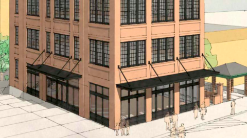 Before/After Images Sponsored Post Off
 atlanta.urbanize.city
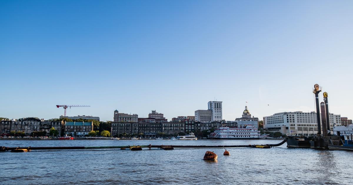
Near Savannah’s River Street, 36-acre island project in works Josh Green Fri, 10/11/2024 - 14:00 A sizable, waterside residential community is in the pipeline with hopes of capitalizing on downtown Savannah's cachet and city growth that’s recently been [described](https://www.atlantafed.org/economy-matters/regional-economics/2024/07/11/savannah-manages-explosive-growth) as “explosive.” National residential developer Trilogy Investment Company has partnered with Atlanta-based real estate investment firm Kingdom Estates to acquire a 36-acre parcel on Hutchinson Island in Savannah’s River District for $17 million. The property is set across the Savannah River from the city’s famed River Street, virtually in the shadow of the Talmadge Memorial Bridge. It’s described by project leaders as being a five-minute drive—or short ferry ride—from Savannah’s downtown Historic District. Plans call for rebranding and redeveloping a project previously planned for the site called [The Reserve at Savannah Harbor](https://www.thereservesavannahharbor.com/), which counts a few large homes and infrastructure in place. The revised name hasn’t been revealed, and project reps tell Urbanize Atlanta no renderings or other images for the project are available yet. According to Trilogy officials, plans now call for building 198 townhomes and single-family houses on Hutchinson Island across multiple phases. Several “acclaimed builders” including Southern Coastal Homes will be brought in to develop the housing, per Trilogy. [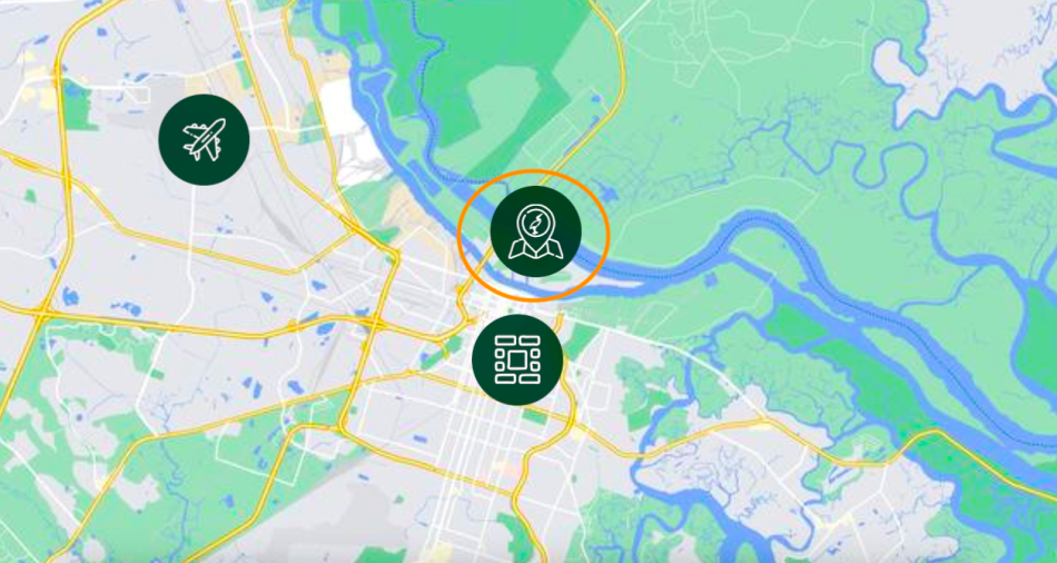](https://atlanta.urbanize.city/sites/default/files/styles/1140w/public/2024-10/Savannah%20Hutchinson%20Island.png?itok=SW-x32Hg "The Reserve At Savannah Harbor") The project's location (circled) in relation to downtown Savannah and the city's airport. The Reserve At Savannah Harbor [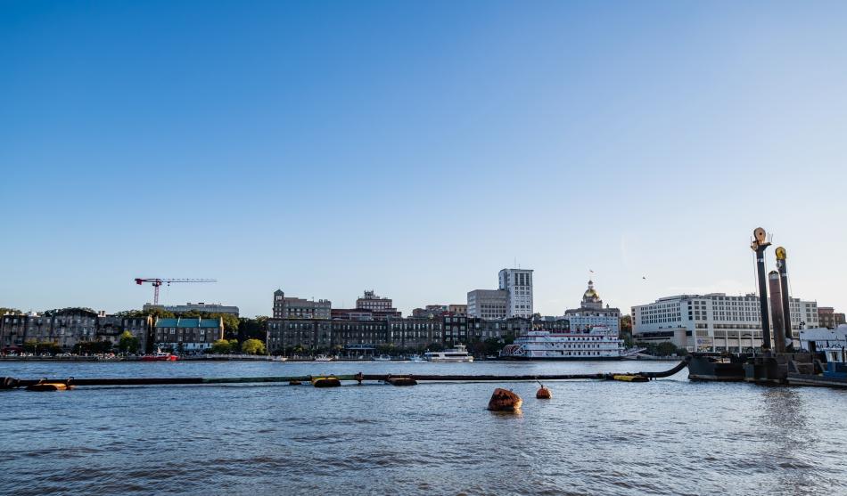](https://atlanta.urbanize.city/sites/default/files/styles/1140w/public/2024-10/Savannah%20River%20Street%20shutterstock_2523380723.jpg?itok=P3ySRhqF "Shutterstock") View of Savannah's River Street from Hutchinson Island. Shutterstock The initial phase, slated to begin construction in January, will see 90 homes total—a mix of townhomes, villas, and single-family dwellings. Trilogy’s schedule calls for delivering that in the third quarter of next year. Some homes will count city views of downtown Savannah, while others will be situated on Hutchison Island’s golf course and terrace, per the developer. Planned amenities call for formal and vegetable gardens, a tennis and pickleball facility with a shaded viewing area, and a large pool with cabanas and daybeds. Trilogy officials say the deal continues their goal of building needed housing throughout the Sunbelt, both for-sale and rent. “We were drawn by the market’s demand for higher-end residential and Hutchinson Island’s prime location,” said Jason Joseph, Trilogy’s CEO and managing partner, in an announcement this week. “[The project] allows us to further the area’s redevelopment and offer a new dimension in housing options within Savannah’s urban core.” [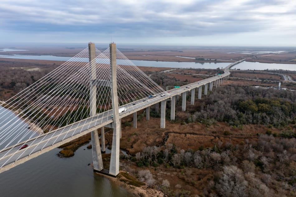](https://atlanta.urbanize.city/sites/default/files/styles/1140w/public/2024-10/Savannah%20Talmadge%20Memorial%20Bridge%20shutterstock_2313808559.jpg?itok=ryLtqLJ_ "Shutterstock") View of the Talmadge Memorial Bridge's connection to Hutchinson Island. The new community will be located to the right. Shutterstock Hutchinson Island’s primary attraction today is the Savannah Convention Center and Westin Hotel, with 18-hole the Club at Savannah Harbor golf course next door. Also on the island, the 35-acre, mixed-use Savannah Harbor project is taking shape with residences, retail, and greenspace. Elsewhere on Hutchinson Island, the [IGY Savannah Harbor Marina](https://www.thereservesavannahharbor.com/post/new-marina-on-hutchinson-island-igy-savannah-harbor-marina)—featuring 100 berths for all types of vessels, including more than 1,000 linear feet for deep-draft superyachts—is set to open near the convention center next spring, per Trilogy. **...** ***Follow us on social media:*** [Twitter](https://twitter.com/UrbanizeATL) / [Facebook](https://www.facebook.com/UrbanizeATL)/**and now:** [Instagram](https://www.instagram.com/urbanizeatlanta_/) • [Savannah news, discussion](https://atlanta.urbanize.city/neighborhood/savannah) (Urbanize Atlanta) Tags [402 Reserve Way](https://atlanta.urbanize.city/tags/402-reserve-way) [Savannah](https://atlanta.urbanize.city/tags/savannah) [The Reserve at Savannah Harbor](https://atlanta.urbanize.city/tags/reserve-savannah-harbor) [Savannah Development](https://atlanta.urbanize.city/tags/savannah-development) [Savannah Projects](https://atlanta.urbanize.city/tags/savannah-projects) [Savannah Construction](https://atlanta.urbanize.city/tags/savannah-construction) [River Street](https://atlanta.urbanize.city/tags/river-street) [Talmadge Memorial Bridge](https://atlanta.urbanize.city/tags/talmadge-memorial-bridge) [Savannah River](https://atlanta.urbanize.city/tags/savannah-river) [Trilogy Investment Company](https://atlanta.urbanize.city/tags/trilogy-investment-company) [Kingdom Estates](https://atlanta.urbanize.city/tags/kingdom-estates) [Southern Coastal Homes](https://atlanta.urbanize.city/tags/southern-coastal-homes) [Downtown Savannah](https://atlanta.urbanize.city/tags/downtown-savannah) [Savannah Convention Center](https://atlanta.urbanize.city/tags/savannah-convention-center) [IGY Savannah Harbor Marina](https://atlanta.urbanize.city/tags/igy-savannah-harbor-marina) [Troon Golf](https://atlanta.urbanize.city/tags/troon-golf) [Club at Savannah Harbor](https://atlanta.urbanize.city/tags/club-savannah-harbor) [Hutchinson Island](https://atlanta.urbanize.city/tags/hutchinson-island) [Cushman and Wakefield](https://atlanta.urbanize.city/tags/cushman-and-wakefield) [Cushman & Wakefield](https://atlanta.urbanize.city/tags/cushman-wakefield-0) [Savannah Harbor](https://atlanta.urbanize.city/tags/savannah-harbor) Images [](https://atlanta.urbanize.city/sites/default/files/styles/1140w/public/2024-10/Savannah%20Hutchinson%20Island.png?itok=SW-x32Hg "The Reserve At Savannah Harbor") The project's location (circled) in relation to downtown Savannah and the city's airport. The Reserve At Savannah Harbor [](https://atlanta.urbanize.city/sites/default/files/styles/1140w/public/2024-10/Savannah%20River%20Street%20shutterstock_2523380723.jpg?itok=P3ySRhqF "Shutterstock") View of Savannah's River Street from Hutchinson Island. Shutterstock [](https://atlanta.urbanize.city/sites/default/files/styles/1140w/public/2024-10/Savannah%20Talmadge%20Memorial%20Bridge%20shutterstock_2313808559.jpg?itok=ryLtqLJ_ "Shutterstock") View of the Talmadge Memorial Bridge's connection to Hutchinson Island. The new community will be located to the right. Shutterstock Subtitle River District community with nearly 200 homes bound for Hutchinson Island Neighborhood [Savannah](https://atlanta.urbanize.city/neighborhood/savannah) Background Image Image 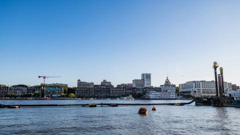 Before/After Images Sponsored Post Off
 atlanta.urbanize.city
West End infill project near Beltline shows signs of life—maybe Josh Green Thu, 10/03/2024 - 16:30 Recent site work has piqued the curiosity of West End residents and neighborhood leadership at a long-vacant corner near the historic district’s commercial core where an injection of rental housing is planned. Whether tree removal at the 1214 Ralph David Abernathy Boulevard site signals the start of actual construction, however, remains unclear. Vacant for years, the corner property in question spans about ½ of an acre where Ralph David Abernathy Boulevard meets Holderness Street, roughly two blocks east of Gordon-White Park and an entrance to the Atlanta Beltline’s Westside Trail. Mall West End, where a [massive redevelopment](https://atlanta.urbanize.city/post/mall-west-end-sells-redevelopment-project-developer-city-says) is scheduled to begin next year, is roughly a half-mile in the other direction. According to site plans, the project calls for 32 one-bedroom apartments in a three-story building, with an attached structure behind that for bike storage, alongside surface parking. [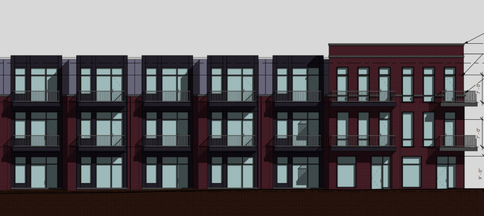](https://atlanta.urbanize.city/sites/default/files/styles/1140w/public/2024-10/lead%201214%20Ralph%20David%20Abernathy.png?itok=md7ltkJ2 "KCME; designs, Place Maker Design") Plans for the Ralph David Abernathy Boulevard facade. KCME; designs, Place Maker Design [](https://atlanta.urbanize.city/sites/default/files/styles/1140w/public/2024-10/lot%202023%201214%20Ralph%20David%20Abernathy%20Blvd%20SW%20.png?itok=Pw7-Th1E "Google Maps") The corner lot in question along Ralph David Abernathy Boulevard in 2023. Google Maps The apartments would range from 487 to 685 square feet. Fifteen percent of them would be reserved for tenants earning 80 percent of the area median income or less, according to the project’s Atlanta-based developer, KCME. KCME specializes in building infill apartments and duplexes. Inquiries to KCME about the status of construction in West End have not been returned. Tony McNeal, president of West End Neighborhood Development, an organization of businesses and neighbors, said his group also remains in the dark as to where the Ralph David Abernathy Boulevard project stands. “We are trying to research this project ourselves,” McNeal wrote to Urbanize Atlanta via email. Building permit records show no activity for the project since last fall—apart from a request to remove seven dying trees in August, which could explain recent work on site. A complaint was filed with the city last month for “illegal tree removal,” but no violation was found, according to the Department of City Planning. KCME’s projects include a [duplex infill build](https://atlanta.urbanize.city/post/amsterdam-walk-duplex-duplex-infill-vacant-lot-sale) in Virginia-Highland near the entrance to Amsterdam Walk, along with Reynoldstown’s [Steelside](https://www.steelsideatl.com/) project and [The Parliament of Edgewood](https://www.theparliamentatl.com/). The company has completed, or is in the process of building, more than 300 units in Atlanta, per KCME’s website. [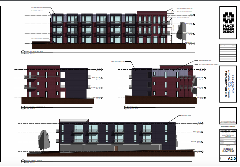](https://atlanta.urbanize.city/sites/default/files/styles/1140w/public/2024-10/1214%20Ralph%20David%20Abernathy.png?itok=PcsxTXXo "KCME; designs, Place Maker Design") KCME; designs, Place Maker Design [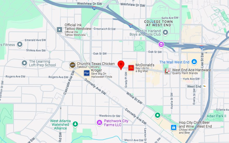](https://atlanta.urbanize.city/sites/default/files/styles/1140w/public/2024-10/1214%20Ralph%20David%20Abernathy%20Blvd%20SW%20map.png?itok=jQggpJ-K "Google Maps") The 1214 Ralph David Abernathy Boulevard property in relation to Mall West End, the Westside Trail, the Lee + White district, and other Southwest Atlanta landmarks. Google Maps According to KCME, the project’s construction schedule would be a little more than a year between groundbreaking and delivery. The total cost is projected at $4 million—with $600,000 of that being land costs, and the rest construction expenditures. Construction was initially scheduled to begin in October last year. Fulton County property records indicate the corner property last sold in 2018 to an LLC called Parkwood Living for $225,000. Find more context and imagery in the gallery above. **...** ***Follow us on social media:*** [Twitter](https://twitter.com/UrbanizeATL) / [Facebook](https://www.facebook.com/UrbanizeATL)/**and now:** [Instagram](https://www.instagram.com/urbanizeatlanta_/) • [West End news, discussion](https://atlanta.urbanize.city/neighborhood/west-end) (Urbanize Atlanta) Tags [1214 Ralph David Abernathy Boulevard SW](https://atlanta.urbanize.city/tags/1214-ralph-david-abernathy-boulevard-sw) [KCME](https://atlanta.urbanize.city/tags/kcme) [West End Neighborhood Development Inc.](https://atlanta.urbanize.city/tags/west-end-neighborhood-development-inc) [Place Maker Design](https://atlanta.urbanize.city/tags/place-maker-design) [Affordable Housing](https://atlanta.urbanize.city/tags/affordable-housing-0) [affordable housing](https://atlanta.urbanize.city/tags/affordable-housing-6) [Southwest Atlanta](https://atlanta.urbanize.city/tags/southwest-atlanta) [Ralph David Abernathy Boulevard](https://atlanta.urbanize.city/tags/ralph-david-abernathy-boulevard) [Beltline](https://atlanta.urbanize.city/tags/beltline) [Westside Trail](https://atlanta.urbanize.city/tags/westside-trail) [The Mall West End](https://atlanta.urbanize.city/tags/mall-west-end) [Gordon-White Park](https://atlanta.urbanize.city/tags/gordon-white-park) Images [](https://atlanta.urbanize.city/sites/default/files/styles/1140w/public/2024-10/lot%202023%201214%20Ralph%20David%20Abernathy%20Blvd%20SW%20.png?itok=Pw7-Th1E "Google Maps") The corner lot in question along Ralph David Abernathy Boulevard in 2023. Google Maps [](https://atlanta.urbanize.city/sites/default/files/styles/1140w/public/2024-10/1214%20Ralph%20David%20Abernathy%20Blvd%20SW%20map.png?itok=jQggpJ-K "Google Maps") The 1214 Ralph David Abernathy Boulevard property in relation to Mall West End, the Westside Trail, the Lee + White district, and other Southwest Atlanta landmarks. Google Maps [](https://atlanta.urbanize.city/sites/default/files/styles/1140w/public/2024-10/lead%201214%20Ralph%20David%20Abernathy.png?itok=md7ltkJ2 "KCME; designs, Place Maker Design") Plans for the Ralph David Abernathy Boulevard facade. KCME; designs, Place Maker Design [](https://atlanta.urbanize.city/sites/default/files/styles/1140w/public/2024-10/1214%20Ralph%20David%20Abernathy.png?itok=PcsxTXXo "KCME; designs, Place Maker Design") KCME; designs, Place Maker Design [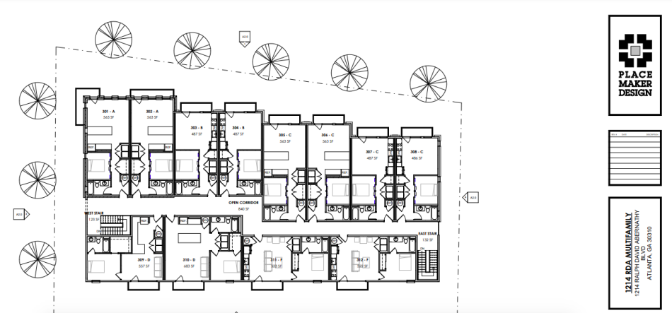](https://atlanta.urbanize.city/sites/default/files/styles/1140w/public/2024-10/Screen%20Shot%202024-10-03%20at%204.36.53%20PM.png?itok=ikDTPvXL "KCME; designs, Place Maker Design") Overview of the site plan where Holderness Street meets Ralph David Abernathy Boulevard. KCME; designs, Place Maker Design [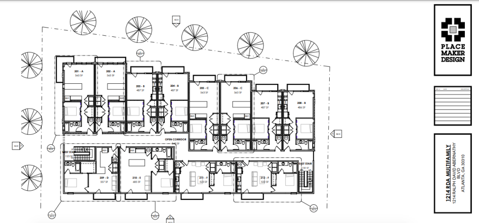](https://atlanta.urbanize.city/sites/default/files/styles/1140w/public/2024-10/2nd%20floor%201214%20Ralph%20David%20Abernathy.png?itok=y39be1Nk "KCME; designs, Place Maker Design") Second-floor plans. KCME; designs, Place Maker Design [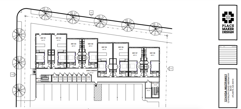](https://atlanta.urbanize.city/sites/default/files/styles/1140w/public/2024-10/1st%20floor%201214%20Ralph%20David%20Abernathy%20first%20floor.png?itok=52XICjKA "KCME; designs, Place Maker Design") Plans for units on the project's first floor. KCME; designs, Place Maker Design Subtitle Proposal on Ralph David Abernathy Boulevard corner calls for more than 30 new residences Neighborhood [West End](https://atlanta.urbanize.city/neighborhood/west-end) Background Image Image 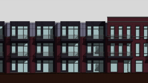 Before/After Images Sponsored Post Off
 atlanta.urbanize.city
Before/after: How Atlanta's skyline has beefed up in recent years Josh Green Thu, 10/03/2024 - 14:33 If Atlanta just *feels* like a bigger city lately, here’s proof you’re not hallucinating. As a fun experiment with the end of 2024 approaching, we set out to contrast the skylines of Midtown and downtown today with those same places about four years ago. By way of the same vantage point used in [the first photograph](https://atlanta.urbanize.city/post/welcome-urbanize-atlanta) to ever publish on Urbanize Atlanta. So here’s how it started: [](https://atlanta.urbanize.city/sites/default/files/styles/1140w/public/2024-10/Atlanta%20Skyline%20late%202020-2021.jpg?itok=vX2Ur5gj "Photo courtesy of Conner Christie, @conner042505") Midtown, left, and downtown Atlanta shown in the winter of 2020-2021. Photo courtesy of Conner Christie, @conner042505 The Midtown/downtown/Connector photo above was taken right as pandemic-stricken 2020 flipped over to 2021. (The amount of parking lots and empty parcels in Midtown being redevelopment at the time seemed truly impressive.) This website debuted in January 2021. Four years later, we count no less than 15 major projects that have delivered or are under construction now in just that one frame. (Some of them block each other from this angle; and yes, this is just one flank of Midtown and downtown with so many projects from Centennial Yards to north Midtown and central Buckhead not shown.) [](https://atlanta.urbanize.city/sites/default/files/styles/1140w/public/2024-10/lead%20Atlanta%20skyline%20October%202024%20.jpg?itok=nJhYtzeE "Urbanize Atlanta") Looking east over the Connector, Midtown, left, and downtown ATL today. Urbanize Atlanta For more context, the large-scale developments that didn’t exist four years ago are pinpointed below, spanning from [Hanover Midtown](https://atlanta.urbanize.city/post/midtown-hanover-tower-retail-leasing-with-zero-parking) to [The Legacy at Centennial](https://atlanta.urbanize.city/post/downtown-tower-images-deluxe-student-housing-debuts-near-centennial-olympic-park), a deluxe downtown student housing high-rise. Also, highlighted in green is a rough approximation of the under-construction [1072 West Peachtree](https://atlanta.urbanize.city/post/1072-west-peachtree-skyscraper-demolition-crews-midtown-tallest-tower) tower’s scale—the tallest building to rise in Atlanta since 1992: [](https://atlanta.urbanize.city/sites/default/files/styles/1140w/public/2024-10/Atlanta%20skyline%20October%202024.jpg?itok=OR_zQJYE "Urbanize Atlanta") Urbanize Atlanta And of course, no before/after skyline comparison would be complete without a slider! Below, see in vivid detail how Midtown’s skyline, especially, has densified with thousands of new apartments and several high-rise office buildings (plus one large, standalone [parking structure](https://atlanta.urbanize.city/post/emorys-prominent-new-parking-garage-sexy-advertised)) in less than four years: Tags [Atlanta Skyline](https://atlanta.urbanize.city/tags/atlanta-skyline) [Midtown Skyline](https://atlanta.urbanize.city/tags/midtown-skyline) [Downtown Skyline](https://atlanta.urbanize.city/tags/downtown-skyline) [Midtown Development](https://atlanta.urbanize.city/tags/midtown-development) [Downtown Development](https://atlanta.urbanize.city/tags/downtown-development-0) [Atlanta Development](https://atlanta.urbanize.city/tags/atlanta-development) [Atlanta Construction](https://atlanta.urbanize.city/tags/atlanta-construction) [Momentum Midtown](https://atlanta.urbanize.city/tags/momentum-midtown) [Campanile](https://atlanta.urbanize.city/tags/campanile) [Campanile Building](https://atlanta.urbanize.city/tags/campanile-building) [Portman](https://atlanta.urbanize.city/tags/portman) [1020 Spring](https://atlanta.urbanize.city/tags/1020-spring) [Spring Quarter](https://atlanta.urbanize.city/tags/spring-quarter) [Sora at Spring Quarter](https://atlanta.urbanize.city/tags/sora-spring-quarter) [1072 West Peachtree](https://atlanta.urbanize.city/tags/1072-west-peachtree) [1072 West Peachtree Street](https://atlanta.urbanize.city/tags/1072-west-peachtree-street) [Generation Atlanta](https://atlanta.urbanize.city/tags/generation-atlanta) [Student Housing](https://atlanta.urbanize.city/tags/student-housing) [Hanover Midtown](https://atlanta.urbanize.city/tags/hanover-midtown) [Hanover](https://atlanta.urbanize.city/tags/hanover) Images [](https://atlanta.urbanize.city/sites/default/files/styles/1140w/public/2024-10/Atlanta%20Skyline%20late%202020-2021.jpg?itok=vX2Ur5gj "Photo courtesy of Conner Christie, @conner042505") Midtown, left, and downtown Atlanta shown in the winter of 2020-2021. Photo courtesy of Conner Christie, @conner042505 [](https://atlanta.urbanize.city/sites/default/files/styles/1140w/public/2024-10/lead%20Atlanta%20skyline%20October%202024%20.jpg?itok=nJhYtzeE "Urbanize Atlanta") Looking east over the Connector, Midtown, left, and downtown ATL today. Urbanize Atlanta [](https://atlanta.urbanize.city/sites/default/files/styles/1140w/public/2024-10/Atlanta%20skyline%20October%202024.jpg?itok=OR_zQJYE "Urbanize Atlanta") Urbanize Atlanta Subtitle Contrasting pandemic-era Midtown, downtown skylines with today Neighborhood [Midtown](https://atlanta.urbanize.city/neighborhood/midtown) Background Image Image 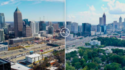 Before/After Images Before Image Image 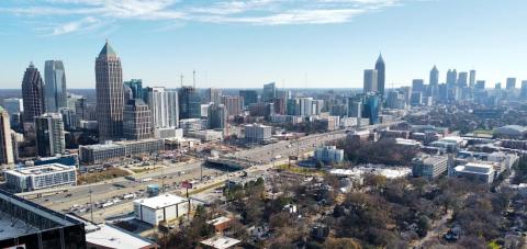 After Image Image 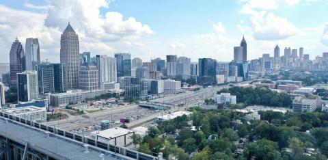 Sponsored Post Off
 atlanta.urbanize.city
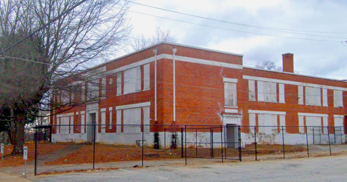
Atlanta to revitalize 8 'surplus' school properties. Here's where exactly Josh Green Wed, 10/02/2024 - 16:19 There’s new life on the horizon for shuttered Atlanta school buildings and empty lots near them, following a recent deal described by city officials as “landmark.” The Atlanta Urban Development Corporation, a local nonprofit entity with a goal of developing underused public land into mixed-income housing, announced an intergovernmental agreement last month with Atlanta Public Schools that calls for transforming eight “surplus” school properties into “community assets” doted across the city, per officials. The deal includes more than 48 acres of total land and vacant or underused facilities. Most of the properties in question are located south and southwest of downtown, from the shadow of Cellairis Amphitheatre at Lakewood around to West End’s commercial core and the Florida Heights neighborhood. [](https://atlanta.urbanize.city/sites/default/files/styles/1140w/public/2024-10/Rosalie%20Wright%20Elementary%20facility%202019.png?itok=TlHga8ne "Google Maps") The former Rosalie Wright Elementary School in 2019. Google Maps The agreement helps set the stage for future revitalization projects by establishing long-term leases for select sites, with properties in West End and Lakewood Heights to see redevelopment first, according to a city announcement. Dr. Bryan Johnson, APS Superintendent, said the agreement with AUDC will allow the district to remake underutilized school sites into “vibrant community hubs that expand access to affordable housing for our families and students and improve the overall quality of life for Atlanta families,” according to a statement. “By leveraging the expertise of AUDC and the resources of APS, we will breathe new life into these properties,” predicted Atlanta Mayor Andre Dickens in the announcement. Before redevelopment kicks off, a community engagement process with public forums, stakeholder meetings, and presentations to local organizations will be held. Following that, a selection committee—comprised of both AUDC and APS representatives—will be tasked with guiding the selection of planning consultants, the Request for Qualifications process, and redevelopment, according to city officials. Following inquiries, city officials have provided Urbanize Atlanta with more context that paints the picture of exactly where the properties in question are, the scope of the sites, and how they're being used, or not. According to city officials, APS’s former Lakewood Heights and Peeples Street sites will be redeveloped first. Find details for the eight surplus sites below, and click on the hyperlinked addresses for Google Maps links to zoom in. **…** **Property name: Former Gilbert Elementary School facility** **Neighborhood:** Betmar LaVilla (near Lakewood Amphitheatre) **Address:** [407 Ashwood Ave., SW](https://www.google.com/maps/place/407+Ashwood+Ave+SW,+Atlanta,+GA+30315/@33.7049972,-84.4017819,15z/data=!4m6!3m5!1s0x88f502fa31472ac7:0xf3afb9a8bff6bc74!8m2!3d33.7058139!4d-84.4026402!16s%2Fg%2F11c43w5d8r?entry=ttu&g_ep=EgoyMDI0MDkzMC4wIKXMDSoASAFQAw%3D%3D) **Acres:** 7.5 **Zip code:** 30315 **Current use:** Atlanta Fire Rescue facility **Cluster:** Carver **NPU:** Y **…** **Property name:** Simpson Road Property **Neighborhood:** Center Hill **Address:** [Joseph E, Boone Boulevard at Sewanee Avenue](https://www.google.com/maps/place/Sewanee+Ave+NW+%26+Joseph+E.+Boone+Blvd+NW,+Atlanta,+GA+30314/@33.7636245,-84.4681483,17z/data=!3m1!4b1!4m6!3m5!1s0x88f51b623e96a287:0x17eeab733e707049!8m2!3d33.7636201!4d-84.465568!16s%2Fg%2F11gf0djbkh?entry=ttu&g_ep=EgoyMDI0MDkzMC4wIKXMDSoASAFQAw%3D%3D) **Acres:** 6.1 **Zip code:** 30314 **Current use:** Vacant wood lot, behind Fredrick Douglass High School, across Sewanee Avenue. **Cluster:** Douglass **NPU:** J **…** **Property name:** Former Collier Heights Elementary site **Neighborhood:** Collier Heights **Address:** [338 Collier Drive NW](https://www.google.com/maps/place/3050+Collier+Dr+NW,+Atlanta,+GA+30318/@33.764054,-84.4909347,669m/data=!3m2!1e3!4b1!4m6!3m5!1s0x88f51b879e9c2b9d:0xa5ea2741e34f5091!8m2!3d33.7640496!4d-84.4883544!16s%2Fg%2F11f4lkryr3?entry=ttu&g_ep=EgoyMDI0MDkzMC4wIKXMDSoASAFQAw%3D%3D) **Acres:** 6.4 **Zip code:** 30318 **Current use:** Vacant lot **Cluster:** Douglass **NPU:** I **…** **Property name:** Former Rosalie Wright Elementary School facility [](https://atlanta.urbanize.city/sites/default/files/styles/1140w/public/2024-10/Rosalie%20Wright%20Elementary%20facility%202019.png?itok=TlHga8ne "Google Maps") The former Rosalie Wright Elementary School in 2019. Google Maps **Neighborhood:** Florida Heights **Address:** [360 Autumn Lane SW](https://www.google.com/maps/place/360+Autumn+Ln+SW,+Atlanta,+GA+30310/@33.7461956,-84.4590549,670m/data=!3m1!1e3!4m6!3m5!1s0x88f51c961e7deb9d:0x60a4e65bd2814a2a!8m2!3d33.7460618!4d-84.45943!16s%2Fg%2F11c5pfr__n?entry=ttu&g_ep=EgoyMDI0MDkzMC4wIKXMDSoASAFQAw%3D%3D) **Acres:** 1.9 **Zip code:** 30310 **Current use:** Vacant building **Cluster:** Mays **NPU:** I **…** **Property name:** Former Dobbs Elementary School site **Neighborhood:** Norwood Manor **Address:** [1965 Lewis Road SE](https://www.google.com/maps/place/1965+Lewis+Rd+SE,+Atlanta,+GA+30315/@33.7007434,-84.3666683,5353m/data=!3m1!1e3!4m6!3m5!1s0x88f502254f6732ed:0x8a7c4043f5fd4eb5!8m2!3d33.700739!4d-84.364088!16s%2Fg%2F11c8946n40?entry=ttu&g_ep=EgoyMDI0MDkzMC4wIKXMDSoASAFQAw%3D%3D) **Acres:** 10.2 **Zip code:** 30315 **Current use:** Vacant lot **Cluster:** South Atlanta **NPU:** Z **…** **Property name:** Former Lakewood Heights Elementary School facility [](https://atlanta.urbanize.city/sites/default/files/styles/1140w/public/2024-10/Lakewood%20Heights%20Elementary%20School%202.png?itok=_XDh5xRn "Google Maps") The former Lakewood Heights Elementary School. Google Maps **Neighborhood:** Lakewood Heights **Address:** [335 Sawtell Ave. SE](https://www.google.com/maps/place/335+Sawtell+Ave+SE,+Atlanta,+GA+30315/@33.705378,-84.3796636,670m/data=!3m2!1e3!4b1!4m6!3m5!1s0x88f50249b231eca5:0x1487f1707fde8a5!8m2!3d33.7053736!4d-84.3770833!16s%2Fg%2F11hcd_k8pp?entry=ttu&g_ep=EgoyMDI0MDkzMC4wIKXMDSoASAFQAw%3D%3D) **Acres:** 2.1 **Zip code:** 30315 **Current use:** Vacant building **Cluster:** South Atlanta **NPU:** Y **…** **Property name:** Forrest Canyon Land site **Neighborhood:** South River Gardens **Address:** [1100 Hendon Road SE](https://www.google.com/maps/place/Hendon+Rd+SE,+Atlanta,+GA+30354/@33.6561978,-84.3548506,5271m/data=!3m1!1e3!4m6!3m5!1s0x88f4fde2b01e0dcb:0x8927d22fb25d387a!8m2!3d33.6560566!4d-84.3548516!16s%2Fg%2F1tdh03sm?entry=ttu&g_ep=EgoyMDI0MDkzMC4wIKXMDSoASAFQAw%3D%3D) **Acres:** 8 **Zip code:** 30354 **Current use:** Vacant lot **Cluster:** South Atlanta **NPU:** Z **…** **Property name:** Former Peeples Street School site (near Mall West End) **Neighborhood:** West End **Address:** [575 Peeples St. SW](https://www.google.com/maps/place/575+Peeples+St+SW,+Atlanta,+GA+30310/@33.7389251,-84.4184527,331m/data=!3m1!1e3!4m5!3m4!1s0x88f50340f1cfa687:0x3a1b8b09ea502711!8m2!3d33.7394984!4d-84.4204958?entry=ttu&g_ep=EgoyMDI0MDkzMC4wIKXMDSoASAFQAw%3D%3D) **Acres:** 6.2 **Zip code:** 30310 **Current use:** Vacant lot **Cluster:** Washington **NPU:** T **...** ***Follow us on social media:*** [Twitter](https://twitter.com/UrbanizeATL) / [Facebook](https://www.facebook.com/UrbanizeATL)/**and now:** [Instagram](https://www.instagram.com/urbanizeatlanta_/) • [Atlanta named best U.S. city for remote work—for 3rd year running](https://atlanta.urbanize.city/post/atl-named-best-us-city-remote-work-3rd-year-running) (Urbanize Atlanta) Tags [Atlanta Urban Development Corporation](https://atlanta.urbanize.city/tags/atlanta-urban-development-corporation) [AUDC](https://atlanta.urbanize.city/tags/audc) [Atlanta Public Schools](https://atlanta.urbanize.city/tags/atlanta-public-schools) [Inter-Governmental Agreement](https://atlanta.urbanize.city/tags/inter-governmental-agreement) [Atlanta Mayor Andre Dickens](https://atlanta.urbanize.city/tags/atlanta-mayor-andre-dickens) [APS](https://atlanta.urbanize.city/tags/aps) [Andre Dickens](https://atlanta.urbanize.city/tags/andre-dickens) [Atlanta Schools](https://atlanta.urbanize.city/tags/atlanta-schools) [Betmar LaVilla](https://atlanta.urbanize.city/tags/betmar-lavilla) [Center Hill](https://atlanta.urbanize.city/tags/center-hill) [South Atlanta](https://atlanta.urbanize.city/tags/south-atlanta) [Florida Heights](https://atlanta.urbanize.city/tags/florida-heights) [Fredrick Douglass High School](https://atlanta.urbanize.city/tags/fredrick-douglass-high-school) [Norwood Manor](https://atlanta.urbanize.city/tags/norwood-manor) [Lakewood Heights](https://atlanta.urbanize.city/tags/lakewood-heights) [South River Gardens](https://atlanta.urbanize.city/tags/south-river-gardens) [West End](https://atlanta.urbanize.city/tags/west-end-0) [Adaptive-Reuse](https://atlanta.urbanize.city/tags/adaptive-reuse-0) [Adaptive-Reuse Development](https://atlanta.urbanize.city/tags/adaptive-reuse-development) [Adaptive-Reuse Project](https://atlanta.urbanize.city/tags/adaptive-reuse-project) [Atlanta Adaptive-Reuse](https://atlanta.urbanize.city/tags/atlanta-adaptive-reuse) [Affordable Housing](https://atlanta.urbanize.city/tags/affordable-housing-0) [affordable housing](https://atlanta.urbanize.city/tags/affordable-housing-6) Images [](https://atlanta.urbanize.city/sites/default/files/styles/1140w/public/2024-10/Lakewood%20Heights%20Elementary%20School%202.png?itok=_XDh5xRn "Google Maps") The former Lakewood Heights Elementary School. Google Maps [](https://atlanta.urbanize.city/sites/default/files/styles/1140w/public/2024-10/Rosalie%20Wright%20Elementary%20facility%202019.png?itok=TlHga8ne "Google Maps") The former Rosalie Wright Elementary School in 2019. Google Maps Subtitle AUDC, Atlanta Public Schools deal calls for creating "community assets" from vacant buildings, lots Neighborhood [Citywide](https://atlanta.urbanize.city/neighborhood/citywide) Background Image Image  Before/After Images Sponsored Post Off
 atlanta.urbanize.city
ATL (reportedly) lands another Super Bowl. What will downtown be then? Josh Green Tue, 10/01/2024 - 08:10 Perhaps you missed it in the torrent of frankly more important news around Atlanta lately, but it appears the fourth Super Bowl in city history is on the horizon—in a part of Atlanta experiencing massive, if not fundamental, changes. The National Football League and Falcons brass haven’t confirmed, but according to a report in [*Sports Business Journal*,](https://www.sportsbusinessjournal.com/Articles/2024/09/26/atl-super-bowl-2028) the NFL is expected to award the second Super Bowl in Mercedes-Benz Stadium history—Super Bowl LXII in February 2028—to Atlanta when team owners meet here later this month. Maybe it’s not the World Cup—and certainly not the Centennial Olympic Games. But for anyone who recalls Atlanta hosting Super Bowl LIII in 2019 (or in 1994 and 2000, for that matter), the big game is a really big deal, both economically and in terms of global exposure. For the 53rd Super Bowl five years ago, the Metro Atlanta Chamber of Commerce pegged the city's Super Bowl windfall at $400 million (some [argued](https://www.ajc.com/business/wes-moss-gdp-atlanta-super-bowl/aB0rzEOHJ7cHFt2s3ay3aK/) it was much lower), with bars (allowed to operate until 4 a.m. that week), restaurants, and hotels packed across town. An entire, temporary arena was erected at Atlantic Station for a Run the Jewels/Foo Fighters concert. Downtown streets were electric for a solid week. Yeah, a big deal. [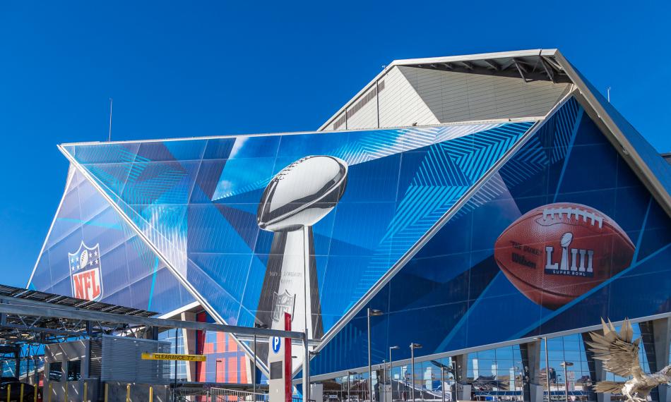](https://atlanta.urbanize.city/sites/default/files/styles/1140w/public/2024-10/Atlanta%20Super%20Bowl%202019%20shutterstock_1291088032.jpg?itok=BUQh-Vj6 "Shutterstock") Mercedes-Benz Stadium decor before the big game on Feb. 3, 2019. Shutterstock [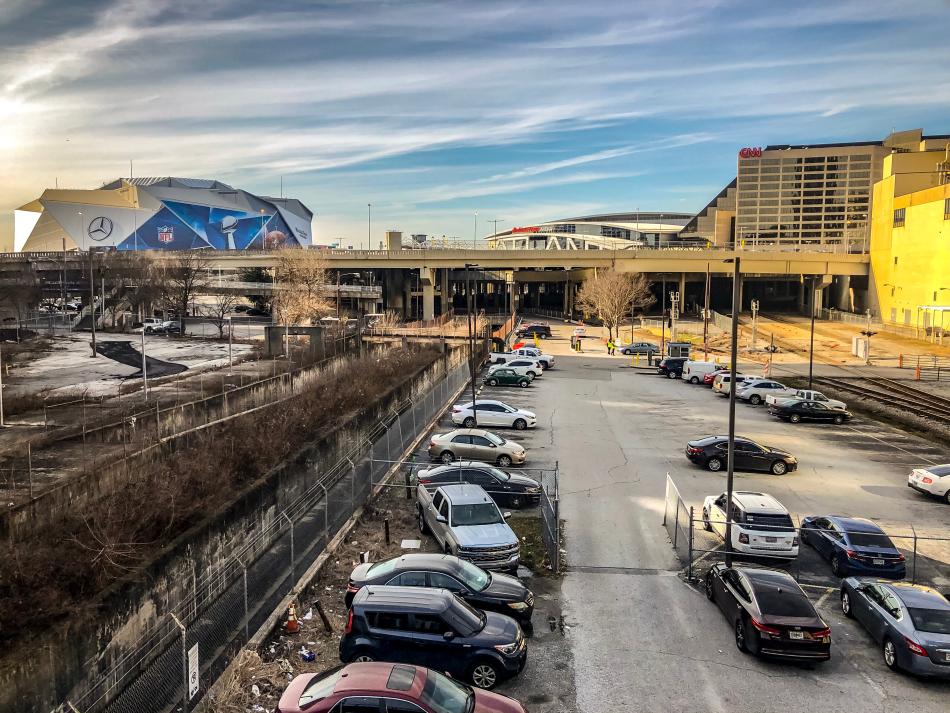](https://atlanta.urbanize.city/sites/default/files/styles/1140w/public/2024-10/Atlanta%20Super%20Bowl%202019%20shutterstock_1299926353.jpg?itok=VU_77MO3 "Shutterstock") The Gulch was more of a lifeless parking lot in the lead up to 2019's Super Bowl. Shutterstock Host cities are already set for the next three Super Bowls, those being New Orleans next year, Santa Clara (home of the 49ers, in 2026), and Los Angeles (2027). But with several [large-scale redevelopment projects](https://atlanta.urbanize.city/post/poll-which-major-downtown-atl-project-most-exciting-beneficial) channeling billions of investments into downtown Atlanta, does any NFL stadium location stand to change as much between now and 2028? The *Sports Business Journal* report notes as much, after pointing out that Atlanta’s last stab at hosting the Super Bowl earned “good reviews” from the legions of sports industry types assembled here in 2019: > > *“The city is walkable, with ample hotel and hospitality inventory. By 2028, three major hotels and the Centennial Yards mixed-use development—none of which was there in 2019—will have been completed in the immediate vicinity of the stadium. It is a proven host to major events, such as the annual SEC Football Championship and Chick-fil-A Peach Bowl. The city also recently won the 2031 NCAA Men’s Final Four.”* > > > But then, a couple of digs: > > *“For all its considerable strengths, Atlanta is not necessarily an obvious choice. It’s far enough north that winter weather can be a concern—ice storms were a problem at the 2000 game there—and its desirability as a glamour destination is a step down from classic hosts such as Miami, L.A., New Orleans, and now Las Vegas.”* > > > All of which begs a few fun questions: [](https://atlanta.urbanize.city/sites/default/files/styles/1140w/public/2024-10/Centennial%20Yards%20Athem%207.jpg?itok=1snvCxnW "Urbanize Atlanta ") Construction progress in May on Centennial Yards' first ground-up new tower to top out, The Mitchell apartments. Urbanize Atlanta If the Super Bowl indeed makes its way back to ATL in ’28, how do you hope downtown will have evolved by then? Or what will downtown actually be, in your humble opinion, if there’s a difference? And can Atlanta ever be, uh, a “glamour destination,” if we even want that? [](https://atlanta.urbanize.city/sites/default/files/styles/1140w/public/2024-10/Centennial%20Yards%20Athem%203.jpg?itok=6p8V82hu "Urbanize Atlanta") Centennial Yards' proximity to downtown stadiums, as seen in May. Urbanize Atlanta **...** ***Follow us on social media:*** [Twitter](https://twitter.com/UrbanizeATL) / [Facebook](https://www.facebook.com/UrbanizeATL)/**and now:** [Instagram](https://www.instagram.com/urbanizeatlanta_/) • [Poll: Which major downtown ATL project is most exciting, beneficial?](https://atlanta.urbanize.city/post/poll-which-major-downtown-atl-project-most-exciting-beneficial) (Urbanize Atlanta) Tags [Downtown Development](https://atlanta.urbanize.city/tags/downtown-development-0) [Super Bowl](https://atlanta.urbanize.city/tags/super-bowl) [Atlanta Super Bowl](https://atlanta.urbanize.city/tags/atlanta-super-bowl) [Mercedes-Benz Stadium](https://atlanta.urbanize.city/tags/mercedes-benz-stadium) [Centennial Yards](https://atlanta.urbanize.city/tags/centennial-yards) [South Downtown](https://atlanta.urbanize.city/tags/south-downtown) [Atlanta Ventures](https://atlanta.urbanize.city/tags/atlanta-ventures) [State Farm Arena](https://atlanta.urbanize.city/tags/state-farm-arena) [Georgia World Congress Center](https://atlanta.urbanize.city/tags/georgia-world-congress-center) [CIM Group](https://atlanta.urbanize.city/tags/cim-group-0) [Downtown Atlanta](https://atlanta.urbanize.city/tags/downtown-atlanta) [Downtown Atlanta Projects](https://atlanta.urbanize.city/tags/downtown-atlanta-projects) [Sports Business Journal](https://atlanta.urbanize.city/tags/sports-business-journal) Images [](https://atlanta.urbanize.city/sites/default/files/styles/1140w/public/2024-10/Centennial%20Yards%20Athem%207.jpg?itok=1snvCxnW "Urbanize Atlanta ") Construction progress in May on Centennial Yards' first ground-up new tower to top out, The Mitchell apartments. Urbanize Atlanta [](https://atlanta.urbanize.city/sites/default/files/styles/1140w/public/2024-10/Centennial%20Yards%20Athem%203.jpg?itok=6p8V82hu "Urbanize Atlanta") Centennial Yards' proximity to downtown stadiums, as seen in May. Urbanize Atlanta [](https://atlanta.urbanize.city/sites/default/files/styles/1140w/public/2024-10/Atlanta%20Super%20Bowl%202019%20shutterstock_1299926353.jpg?itok=VU_77MO3 "Shutterstock") The Gulch was more of a lifeless parking lot in the lead up to 2019's Super Bowl. Shutterstock [](https://atlanta.urbanize.city/sites/default/files/styles/1140w/public/2024-10/Atlanta%20Super%20Bowl%202019%20shutterstock_1291088032.jpg?itok=BUQh-Vj6 "Shutterstock") Mercedes-Benz Stadium decor before the big game on Feb. 3, 2019. Shutterstock Subtitle Because three and 1/2 years is an eternity down here Neighborhood [Downtown](https://atlanta.urbanize.city/neighborhood/downtown-0) Background Image Image 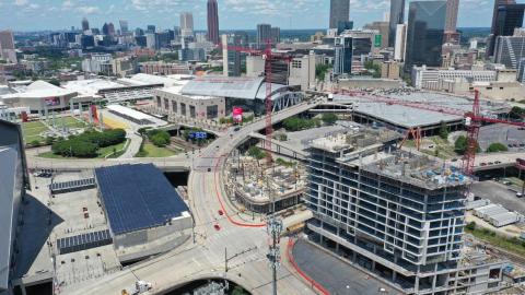 Before/After Images Sponsored Post Off
 atlanta.urbanize.city
Gwinnett's 300-acre, mixed-use office park redo takes steps forward Josh Green Mon, 09/30/2024 - 16:16 The planned conversion of a Gwinnett County corporate campus into a hub of housing, retail, and industrial uses has recently taken significant steps toward beginning construction, marking what project leaders call a win for the county and State of Georgia. Two years ago, Foxfield LLC and global real estate manager AEW Capital Management bought nearly 300 acres just south of where Ga. Highway 316 meets Sugarloaf Parkway, west of downtown Lawrenceville and two miles east of Interstate 85 in central Gwinnett. The mixed-use project has been dubbed Sugarloaf Logistics Hub. The site today is home to a six-building corporate office setting that spans 740,000 square feet. But Foxfield and AEW envision a master-planned campus with more than 2.2 million square feet, blending up to 800 residences with seven new buildings (ranging from 120,000 to more than 600,000 square feet) for industrial, warehouse, and logistics uses. [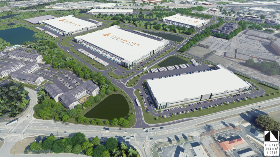](https://atlanta.urbanize.city/sites/default/files/styles/1140w/public/2024-09/Aerial%20Rendering%20of%20Sugarloaf%20Logistics%20Hub.png?itok=QdyDp86i "Courtesy of Foxfield LLC, AEW Capital Management; designs, Pieper O'Brien Herr Architects ") Overview of mixed-use plans at the Sugarloaf Logistics Hub. Courtesy of Foxfield LLC, AEW Capital Management; designs, Pieper O'Brien Herr Architects Project officials announced Monday that food distributor Souto Foods—a Gwinnett-based subsidiary of Alex Lee, specializing in products from Latin America and the Caribbean—has signed a lease for a roughly 200,000-square-foot building at the Sugarloaf campus. Souto Foods plans to invest $28 million in the site and hire 70 new employees in the county, rooting a significant portion of its Southeastern base at the facility. The Sugarloaf Logistics Hub team has also sold more than 13 acres of the site to Atlanta-based housing developer Westplan Investors. According to Foxfield and AEW reps, the land deal will set the stage for about 330 multifamily units to be built near one edge of the campus along Sugarloaf Parkway and Cruse Road. The thinking goes that Sugarloaf Logistics Hub employees will also be attracted to renting on site. “Surrounded by abundant employers, amenities, and demand drivers, this well-located opportunity aligns perfectly with our strategy of developing high-quality multifamily residences across Sunbelt growth markets,” Kenny Budd, Westplan regional development partner, said in a prepared statement. According to project leaders, Sugarloaf Logistics Hub is being designed to embrace the site’s natural features, including a lake, creeks, streams, tributaries, and walking paths. [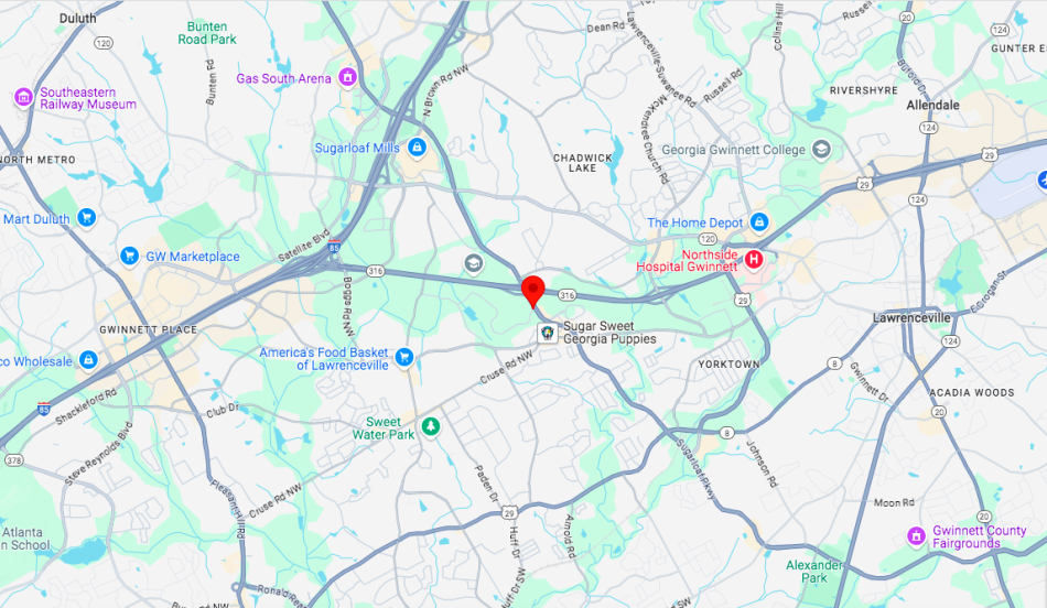](https://atlanta.urbanize.city/sites/default/files/styles/1140w/public/2024-09/Sugarloaf%20Logistics%20Hub%20map%20.png?itok=l6hNAyxP "Google Maps") Sugarloaf Logistics Hub's location where Ga. Highway 316 meets Sugarloaf Parkway, in relation to Interstate 85 and downtown Lawrenceville. Google Maps On the residential front, plans call for 700 to 800 units to eventually be built, blending single-story flats apartments and townhomes. Elsewhere, five retail pad sites will be situated along Sugarloaf Parkway, an important traffic corridor around the central section of Georgia’s second-largest county. Project heads say the location, situated close to I-85, is well-suited for light manufacturing, last-mile logistics, and food uses that can take advantage Gwinnett’s [growing population](https://atlanta.urbanize.city/post/metro-atl-population-63k-more-people-report-past-year) and labor base. Construction of Sugarloaf Logistics Hub is scheduled to start in the second quarter of 2025. **...** ***Follow us on social media:*** [Twitter](https://twitter.com/UrbanizeATL) / [Facebook](https://www.facebook.com/UrbanizeATL)/**and now:** [Instagram](https://www.instagram.com/urbanizeatlanta_/) • [Gwinnett County news, discussion](https://atlanta.urbanize.city/neighborhood/gwinnett-county) (Urbanize Atlanta) Tags [Sugarloaf Parkway at Ga. Highway 316](https://atlanta.urbanize.city/tags/sugarloaf-parkway-ga-highway-316) [Sugarloaf Logistics Hub](https://atlanta.urbanize.city/tags/sugarloaf-logistics-hub) [Gwinnett County](https://atlanta.urbanize.city/tags/gwinnett-county) [Gwinnett County Development](https://atlanta.urbanize.city/tags/gwinnett-county-development) [Foxfield](https://atlanta.urbanize.city/tags/foxfield) [AEW Capital Management](https://atlanta.urbanize.city/tags/aew-capital-management) [Souto Foods](https://atlanta.urbanize.city/tags/souto-foods) [JLL](https://atlanta.urbanize.city/tags/jll) [OnPace Partners](https://atlanta.urbanize.city/tags/onpace-partners) [NAI Brannen Goddard](https://atlanta.urbanize.city/tags/nai-brannen-goddard) [Westplan Investors](https://atlanta.urbanize.city/tags/westplan-investors) [Lawrenceville](https://atlanta.urbanize.city/tags/lawrenceville) [OTP](https://atlanta.urbanize.city/tags/otp) [Gwinnett](https://atlanta.urbanize.city/tags/gwinnett) [Sugarloaf Parkway](https://atlanta.urbanize.city/tags/sugarloaf-parkway) [Ga. Highway 316](https://atlanta.urbanize.city/tags/ga-highway-316) [Pieper O'Brien Herr Architects](https://atlanta.urbanize.city/tags/pieper-obrien-herr-architects) [Alex Lee](https://atlanta.urbanize.city/tags/alex-lee) Images [](https://atlanta.urbanize.city/sites/default/files/styles/1140w/public/2024-09/Sugarloaf%20Logistics%20Hub%20map%20.png?itok=l6hNAyxP "Google Maps") Sugarloaf Logistics Hub's location where Ga. Highway 316 meets Sugarloaf Parkway, in relation to Interstate 85 and downtown Lawrenceville. Google Maps [](https://atlanta.urbanize.city/sites/default/files/styles/1140w/public/2024-09/Aerial%20Rendering%20of%20Sugarloaf%20Logistics%20Hub.png?itok=QdyDp86i "Courtesy of Foxfield LLC, AEW Capital Management; designs, Pieper O'Brien Herr Architects ") Overview of mixed-use plans at the Sugarloaf Logistics Hub. Courtesy of Foxfield LLC, AEW Capital Management; designs, Pieper O'Brien Herr Architects Subtitle Sugarloaf Logistics Hub campus project calls for up to 800 homes, distribution centers, more Neighborhood [Gwinnett County](https://atlanta.urbanize.city/neighborhood/gwinnett-county) Background Image Image 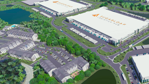 Before/After Images Sponsored Post Off
 atlanta.urbanize.city
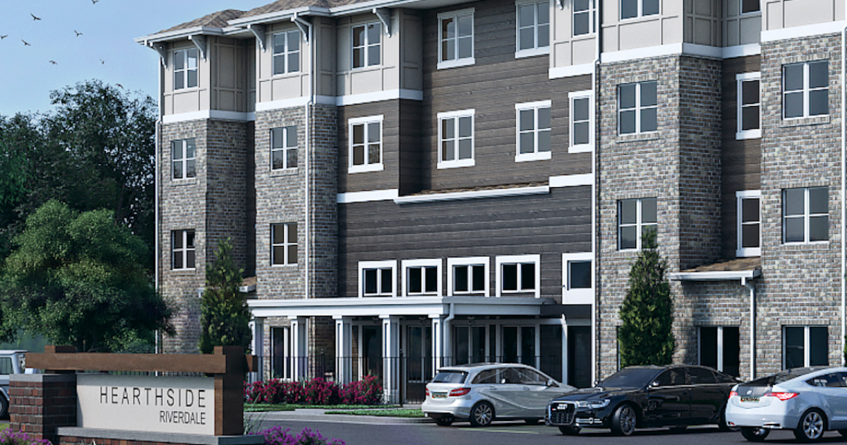
Developers: Density, affordable options bound for downtown Riverdale Josh Green Wed, 09/25/2024 - 08:01 Due south of Atlanta’s airport, a multifamily complex has begun construction to add density near Riverdale’s main commercial strip and a regional greenspace. Plans for HearthSide Riverdale call for 70 units of senior housing where single-family houses now stand at 6795 Powers St. in the Clayton County city. The site is a block off Ga. Highway 85, situated behind a Del Taco on Riverdale’s main hub of retail, just west of Riverdale City Hall and Riverdale Regional Park. It’s about five miles south of Hartsfield-Jackson Atlanta International Airport. According to Swinerton, a California-based general contractor with offices nationwide, demolition of the existing homes has begun at the 2.64-acre Riverdale site. The project marks the company’s sixth with Atlanta-based developer OneStreet Residential. The building was designed by Boulder, Colo.-based DTJ Design. Previous HearthSide-branded projects include complexes in Tucker, Lawrenceville, and Peachtree City. HearthSide Riverdale calls for a single gated building with a mix of market-rate and affordable apartments with either one or two bedrooms. [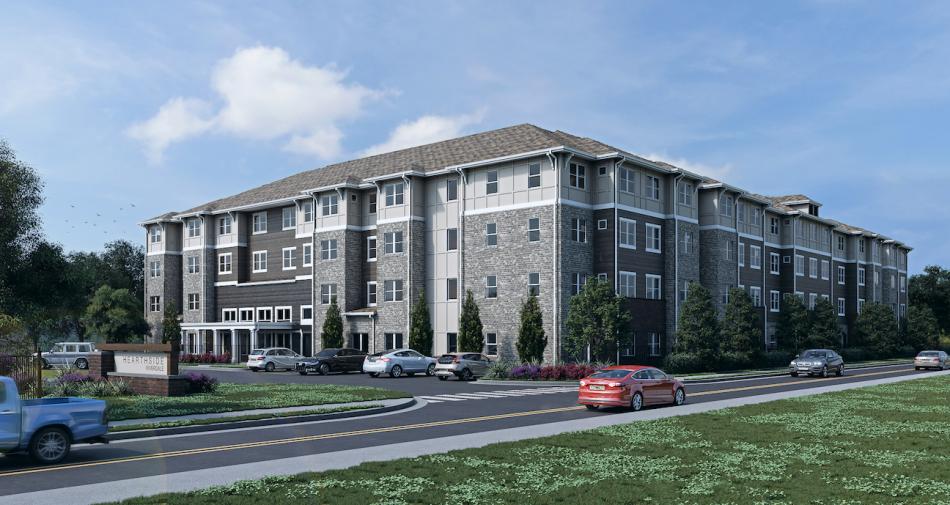](https://atlanta.urbanize.city/sites/default/files/styles/1140w/public/2024-09/HEARTHSIDE%20RIVERDALE%20FINAL%20-%20UPDATED.jpg?itok=-3T0evh8 "Courtesy of Swinerton; designs, DTJ Design") Courtesy of Swinerton; designs, DTJ Design [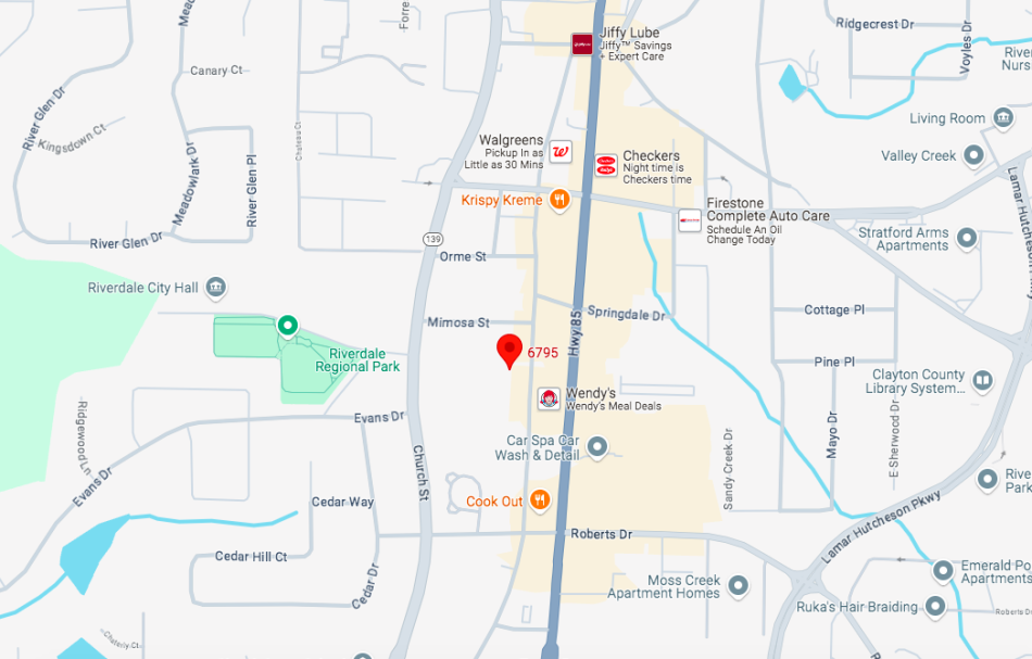](https://atlanta.urbanize.city/sites/default/files/styles/1140w/public/2024-09/HearthSide%20Riverdale%20map%201.png?itok=RyqxGssl "Google Maps") The Riverdale site's proximity to City Hall and food options along Ga. Highway 85. Google Maps Monthly rents haven’t been specified. But according to the development team, just a dozen apartments will rent at market rates, while the other 58 will be reserved for seniors earning less than 60 percent of the area median income. Pet-friendly amenities at the Riverdale complex will include a fitness center, garden beds, a community room, and laundry facilities. One unique facet will be a 700-square-foot bistro open to both HearthSide residents and the general public, according to Swinerton officials. The $16.4 million Riverdale project is scheduled to be finished in early 2026. For the Hearthside venture in Lawrenceville, which was finished last year, Swinerton received the Construction Management Association of America’s South Atlanta Project Achievement Award. The company’s Atlanta Division has built $358 million of commercial and multifamily projects since expanding to the Southeast in 2018. That tally includes more than 11,000 finished residential units throughout metro Atlanta, with more than 700 under construction or in the development pipeline, according to Swinerton officials. [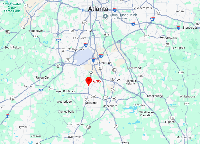](https://atlanta.urbanize.city/sites/default/files/styles/1140w/public/2024-09/HearthSide%20Riverdale%20map%202.png?itok=janXqnQy "Google Maps") The 6795 Powers St. site in relation to downtown Atlanta and the city's airport (shaded). Google Maps **...** ***Follow us on social media:*** [Twitter](https://twitter.com/UrbanizeATL) / [Facebook](https://www.facebook.com/UrbanizeATL)/**and now:** [Instagram](https://www.instagram.com/urbanizeatlanta_/) • [Clayton County news, discussion](https://atlanta.urbanize.city/neighborhood/clayton-county) (Urbanize Atlanta) Tags [6795 Powers Street](https://atlanta.urbanize.city/tags/6795-powers-street) [Riverdale](https://atlanta.urbanize.city/tags/riverdale-0) [HearthSide Riverdale](https://atlanta.urbanize.city/tags/hearthside-riverdale) [Swinerton](https://atlanta.urbanize.city/tags/swinerton-0) [OTP](https://atlanta.urbanize.city/tags/otp) [South OTP](https://atlanta.urbanize.city/tags/south-otp) [Atlanta Airport](https://atlanta.urbanize.city/tags/atlanta-airport) [Construction Management Association of America](https://atlanta.urbanize.city/tags/construction-management-association-america) [OneStreet Residential](https://atlanta.urbanize.city/tags/onestreet-residential) [DTJ Design](https://atlanta.urbanize.city/tags/dtj-design) [Affordable Housing](https://atlanta.urbanize.city/tags/affordable-housing-0) [Atlanta Development](https://atlanta.urbanize.city/tags/atlanta-development) [Atlanta Construction](https://atlanta.urbanize.city/tags/atlanta-construction) [Riverdale City Hall](https://atlanta.urbanize.city/tags/riverdale-city-hall) [Clayton County](https://atlanta.urbanize.city/tags/clayton-county) [Riverdale Regional Park](https://atlanta.urbanize.city/tags/riverdale-regional-park) [senior housing](https://atlanta.urbanize.city/tags/senior-housing) [affordable senior housing](https://atlanta.urbanize.city/tags/affordable-senior-housing) [HearthSide Lawrenceville](https://atlanta.urbanize.city/tags/hearthside-lawrenceville) [Hartsfield-Jackson Atlanta International Airport](https://atlanta.urbanize.city/tags/hartsfield-jackson-atlanta-international-airport) Images [](https://atlanta.urbanize.city/sites/default/files/styles/1140w/public/2024-09/HearthSide%20Riverdale%20map%202.png?itok=janXqnQy "Google Maps") The 6795 Powers St. site in relation to downtown Atlanta and the city's airport (shaded). Google Maps [](https://atlanta.urbanize.city/sites/default/files/styles/1140w/public/2024-09/HEARTHSIDE%20RIVERDALE%20FINAL%20-%20UPDATED.jpg?itok=-3T0evh8 "Courtesy of Swinerton; designs, DTJ Design") Courtesy of Swinerton; designs, DTJ Design [](https://atlanta.urbanize.city/sites/default/files/styles/1140w/public/2024-09/HearthSide%20Riverdale%20map%201.png?itok=RyqxGssl "Google Maps") The Riverdale site's proximity to City Hall and food options along Ga. Highway 85. Google Maps Subtitle HearthSide-branded project begins construction due south of Atlanta airport Neighborhood [Southside](https://atlanta.urbanize.city/neighborhood/southside) Background Image Image 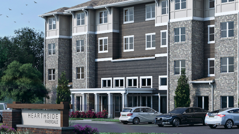 Before/After Images Sponsored Post Off
 atlanta.urbanize.city
Gwinnett's next transit referendum vote is weeks away. Will it pass? Josh Green Tue, 09/24/2024 - 14:09 Today marks exactly six weeks until Americans will be asked to make a monumental, potentially historic decision: Will Gwinnett County see $17 billion worth of transit investment in its future, or not? Another way of framing the question: For Georgia’s second most populous county—with a population that [topped 1 million](https://atlanta.urbanize.city/post/metro-atl-population-63k-more-people-report-past-year) for the first time in history this year—could the third time for referendum votes in the past five years be a charm? Back in June, the Gwinnett County Board of Commissioners voted 4-1 in favor of placing a SPLOST transit referendum on the Nov. 5 General Election ballot, which also includes the presidential election. Should Gwinnett voters approve the extra funding for transit—historically, and infamously if you ask Atlanta urbanists, they have not—the transit referendum would impose a 1 percent sales tax for up to 30 years. According to county leadership, the estimated $17 billion culled from consumer spending in Gwinnett would fund up to [75 transit projects](https://www.gwinnettcounty.com/static/departments/transportation/pdf/gwinnett-county-referendum-project-list-exhibit-a-final.pdf) around the county, with an emphasis on expanding bus and microtransit options. But here’s the kicker: It would *not* include MARTA expansion or heavy rail in any capacity. MARTA branching into the northeast OTP suburbs was one facet of transit referendums that failed most recently in Gwinnett in both 2019 and 2020. The latter, a $12 billion plan, was rejected by a [**razor-thin**](https://www.ajc.com/news/atlanta-news/gwinnett-county-transit-vote-fails-recount-possible/YEONKUUBMBHXHO565CO7IEFDFU/) margin. The overarching goal now, as supporters of the SPLOST measure at the county level have previously told reporters, is to create a scalable transit system that allows Gwinnettians to travel anywhere in the county without a car, setting a blueprint for suburban transit in the metro that could lift Gwinnett onto “the world stage” in terms of doing viable transit right. Should voters approve, Gwinnett would make substantial bets on buses and microtransit, an on-demand, shared-service [**operating**](https://www.gwinnettcounty.com/web/gwinnett/departments/transportation/gwinnettcountytransit/microtransit) with shuttles and vans that allows people to order rides via phones and pay $3 per trip. Gwinnett currently operates microtransit but in a limited capacity. Highlights of the $17 billion transit plan unanimously approved by commissioners in September 2023—following a year and ½ of public input and revisions—would include: > > *Expanded microtransit by 2033 across the entire county;* > > > *Additional, modernized transfer facilities throughout Gwinnett;* > > > *Extended and reconfigured bus routes. Additions would include a bus-rapid-transit line between Doraville’s MARTA station and Lawrenceville, the county seat, and high-frequency buses elsewhere. (The BRT route, as advocates have noted, could be a viable means of getting to Hartsfield-Jackson International Atlanta Airport without a personal vehicle or pricey rideshare);* > > > *Express bus routes from Snellville in southeast Gwinnett and Mall of Georgia in the far north down to Atlanta’s airport, providing an additional airport connection for residents in those sections of the county;* > > > *Gwinnett transit services would operate on Sundays, which they currently don’t.* > > > [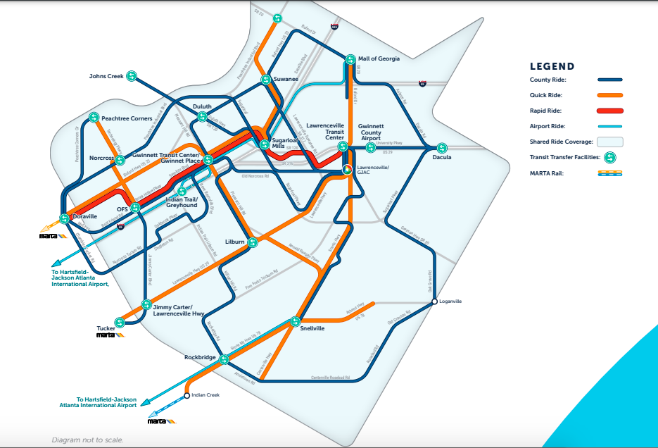](https://atlanta.urbanize.city/sites/default/files/styles/1140w/public/2024-09/Ride%20Gwinnett%20Transit%20diagram%20.png?itok=Xl1LtUFR "Ride Gwinnett") Ride Gwinnett's proposed transit service diagram, should November's SPLOST measure pass. Ride Gwinnett Gwinnett’s [track record](https://www.ajc.com/news/local-govt--politics/gwinnett-marta-referendum-has-failed/fzmvZ0KPZAOzGw7rlL9NPJ/) with tax-funded, transit-expansion proposals appears daunting, with four MARTA rejections dating back to 1971 and 1990, in addition to the two more recent failed efforts. But the county is a vastly different place these days, with three times the population as the early 1990s and a shift in politics and identity from suburban conservative to more progressive and remarkably diverse. While its growth today isn’t on par with much of the boom-times 1980s and ’90s, Gwinnett remains firmly among the region’s leaders. According to the Atlanta Regional Commission’s 2024 population estimates from July, Gwinnett packed on another 14,900 residents over the year ending in April. That was the second most in metro Atlanta, behind only Fulton County’s 17,400 boost in population (with the City of Atlanta factored in). Gwinnett also finished second in terms of single-family and multifamily building permits issued (5,423), trailing only Atlanta proper (7,621) in that category over the past year. As of July, ARC officials pegged Gwinnett’s population at 1,012,112, marking just the third county in Georgia to edge over 1 million residents. Will these people support a significant tax outlay to boost transit options? We shall see, in six weeks. In the meantime, here’s a preview of the specific SPLOST referendum ballot language Gwinnettians will see in November: > > *“Shall a special one (1%) percent sales and use tax be imposed in the special district consisting of Gwinnett County for a period of time not to exceed thirty (30) years and for the raising of funds for transit projects?”* > > > **...** ***Follow us on social media:*** [Twitter](https://twitter.com/UrbanizeATL) / [Facebook](https://www.facebook.com/UrbanizeATL)/**and now:** [Instagram](https://www.instagram.com/urbanizeatlanta_/) • [Gwinnett County news, discussion](https://atlanta.urbanize.city/neighborhood/gwinnett-county) (Urbanize Atlanta) Tags [Gwinnett County](https://atlanta.urbanize.city/tags/gwinnett-county) [Atlanta Transit](https://atlanta.urbanize.city/tags/atlanta-transit) [The ATL](https://atlanta.urbanize.city/tags/atl-0) [Nicole Love Hendrickson](https://atlanta.urbanize.city/tags/nicole-love-hendrickson) [Atlanta-Region Transit Link Authority](https://atlanta.urbanize.city/tags/atlanta-region-transit-link-authority) [Alternate Transportation](https://atlanta.urbanize.city/tags/alternate-transportation) [Alternative Transportation](https://atlanta.urbanize.city/tags/alternative-transportation) [OTP](https://atlanta.urbanize.city/tags/otp) [Gwinnett Transit](https://atlanta.urbanize.city/tags/gwinnett-transit) [Transit Plans](https://atlanta.urbanize.city/tags/transit-plans) [Bus-Rapid Transit](https://atlanta.urbanize.city/tags/bus-rapid-transit-1) [Microtransit](https://atlanta.urbanize.city/tags/microtransit) [Council for Quality Growth](https://atlanta.urbanize.city/tags/council-quality-growth) [Gwinnett County Board of Commissioners](https://atlanta.urbanize.city/tags/gwinnett-county-board-commissioners) [Gwinnett Referendum](https://atlanta.urbanize.city/tags/gwinnett-referendum) [Ride Gwinnett](https://atlanta.urbanize.city/tags/ride-gwinnett) [Gwinnett County population](https://atlanta.urbanize.city/tags/gwinnett-county-population) [Gwinnett Population](https://atlanta.urbanize.city/tags/gwinnett-population) [SPLOST](https://atlanta.urbanize.city/tags/splost) Images [](https://atlanta.urbanize.city/sites/default/files/styles/1140w/public/2024-09/Ride%20Gwinnett%20Transit%20diagram%20.png?itok=Xl1LtUFR "Ride Gwinnett") Ride Gwinnett's proposed transit service diagram, should November's SPLOST measure pass. Ride Gwinnett Subtitle Transit SPLOST plans totaling $17 billion are at stake come November Neighborhood [Gwinnett County](https://atlanta.urbanize.city/neighborhood/gwinnett-county) Background Image Image 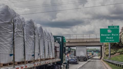 Before/After Images Sponsored Post Off
 atlanta.urbanize.city
New details, glimpses emerge for Underground Atlanta sky-rise Josh Green Fri, 09/20/2024 - 08:10 It’s been a seismic week for urban-planning news around Atlanta, especially in [downtown](https://atlanta.urbanize.city/neighborhood/downtown-0), and chief among those happenings is confirmation that hundreds of new residences are bound for Underground Atlanta in the district’s first large-scale, ground-up development in decades. Following an Invest Atlanta vote Thursday that project leaders call crucial, the development team behind the 30-story proposal at Underground shed more light on where the tower stands today—and how it will look and function, should timelines go according to plan, sometime in 2027. The 405-unit project is a joint venture between Underground owner Lalani Ventures and Exact Capital, a New York City-based real estate firm whose other work in Atlanta includes the nearly finished [Skyline apartment building](https://atlanta.urbanize.city/post/southside-beltline-skyline-apartments-photos-first-residential-tower-rounds-shape) near the Beltline’s Southside Trail. The tower’s 76 Wall St. site—bordered by Peachtree Street to the west, Wall Street to the north, Pryor Street to the east, and Upper Alabama Street to the south—is at a section of Underground called fountain plaza, across the street from two parking decks. The site is also steps from MARTA’s Five Points station, Atlanta’s largest and busiest transit hub, but contrary to ATL urbanist wishes, the tower won’t be totally bereft of new parking. [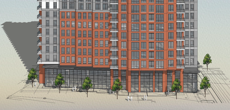](https://atlanta.urbanize.city/sites/default/files/styles/1140w/public/2024-09/Underground%20Atlanta%20tower%20base.png?itok=O439978J "Designs, Niles Bolton Associates; courtesy of Underground Atlanta. ") Closer look at the 76 Wall St. proposal's base floors. (We've asked for clarification on which cross-streets these are and will relay any details that come.)Designs, Niles Bolton Associates; courtesy of Underground Atlanta. According to Jacob Vallo, Lalani Ventures’ chief investment officer and a former MARTA executive, the Underground tower’s plans call for a “well below market parking-to-unit ratio” that will bank on “phenomenal transit access and the walkability of downtown,” according to an announcement issued by Underground officials. The mixed-income tower, for now, is still considered to be in planning phases led by Lalani Ventures and Exact Capital. Atlanta-based architects Niles Bolton Associates are handling design, engineering, and permitting. The firm’s recent work in Atlanta includes the posh student-housing tower [Whistler](https://atlanta.urbanize.city/post/georgia-tech-student-tower-whistler-tower-posh-photos-rents) near Georgia Tech and a mixed-use, Novel-branded [proposal](https://atlanta.urbanize.city/post/blandtown-mixed-use-development-construction-west-midtown) in Blandtown. Underground owner Shaneel Lalani, Lalani Ventures CEO, and Craig Livingston and Michael Callaghan of Exact Capital have estimated the tower will cost $160 million to develop. Invest Atlanta’s board this week approved an inducement for a $40 million tax exempt bond issuance that project leaders say will help the project pencil out with below-market apartments baked in. (That’s more than Lalani paid for the entire Underground property in 2020.) Before the project closes on its construction loan, which is predicted to happen sometime next year, the same board will have another opportunity to vet the project before giving a final resolution, according to Underground reps. [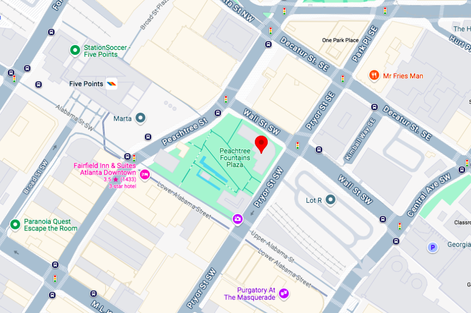](https://atlanta.urbanize.city/sites/default/files/styles/1140w/public/2024-09/Underground%20Atlanta%20tower%2076%20Wall%20St.%20map.png?itok=5EVHZ80u "Google Maps ") Planned location of the 30-story Underground Atlanta residential tower, next to main plazas and fountains. Google Maps Plans call for 163 of the 405 apartments to be reserved as affordable housing for renters earning 60 percent or less of the area median income. All apartments will be housed in the same tower structure, sharing the same amenities. Lalani Ventures and Exact Capital’s timeline calls for breaking ground on the building by the end of next year, which means construction should be well underway by the time FIFA World Cup crowds flock into Atlanta in summer 2026. Nearby, Lalani is also [**planning to convert**](https://www.bisnow.com/atlanta/news/multifamily/underground-atlanta-owner-to-convert-downtown-office-tower-to-aparments-120462) two-thirds of the One Park Tower he owns at 34 Peachtree St. into housing. Nearly four years after Lalani scooped up the historic, 400,000-square-foot complex spanning 12 downtown acres for $31.6 million, he says an arts and retail-focused “renaissance” is afoot. [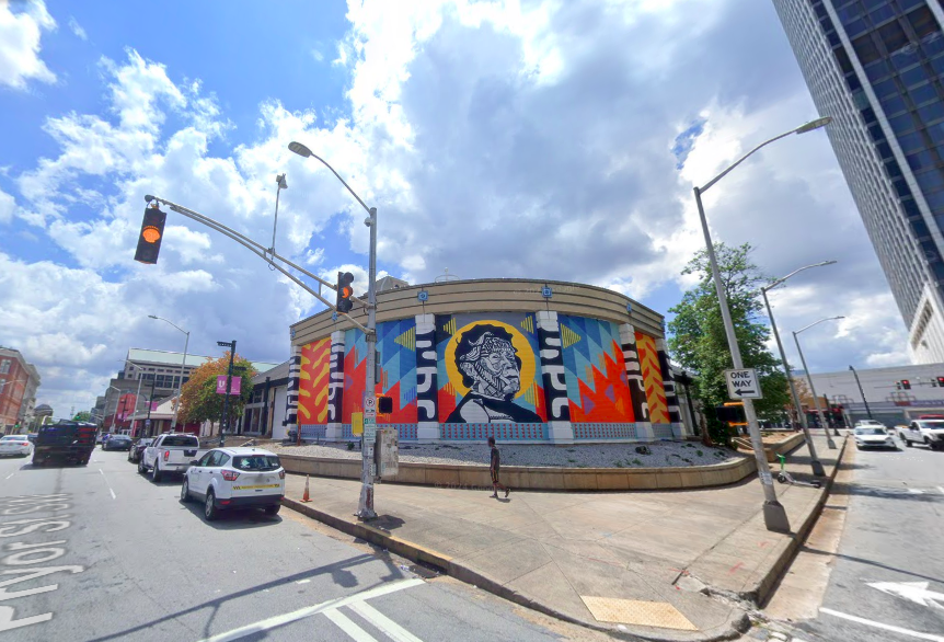](https://atlanta.urbanize.city/sites/default/files/styles/1140w/public/2024-09/Underground%20Atlanta%20tower%2076%20Wall%20St.%20July%202024.png?itok=r6Ar0GZ5 "Google Maps") As seen in July, the 76 Wall St. building where the residential tower is planned at Underground Atlanta's northern edge. Google Maps Underground’s growing tenant rosters includes newer additions such at Atlanta Comedy Theatre, Insomnia Night Club, Utopia Restaurant Bar & Lounge, speakeasy and theater Pigalle by Paris on Ponce, and The Frisky Whisker ATL, described as an “eclectic sound gallery and listening lounge and cafe, featuring dozens of friendly cats.” Seven art galleries are operating at Lower Underground, with two more at Upper Underground, and The Masquerade music and events venue is on pace to host 700 shows this year. Beloved Atlanta nightclub MJQ Concourse is also completing renovations now on the former Dante’s Down the Hatch space, according to Lalani. “This [apartment tower] is part of our overall vision to create Atlanta’s top arts and entertainment community,” Lalani said in a statement. “Having residents live right here will create more vibrancy for this beloved property with historic roots, which in turn will have a great impact on downtown.” [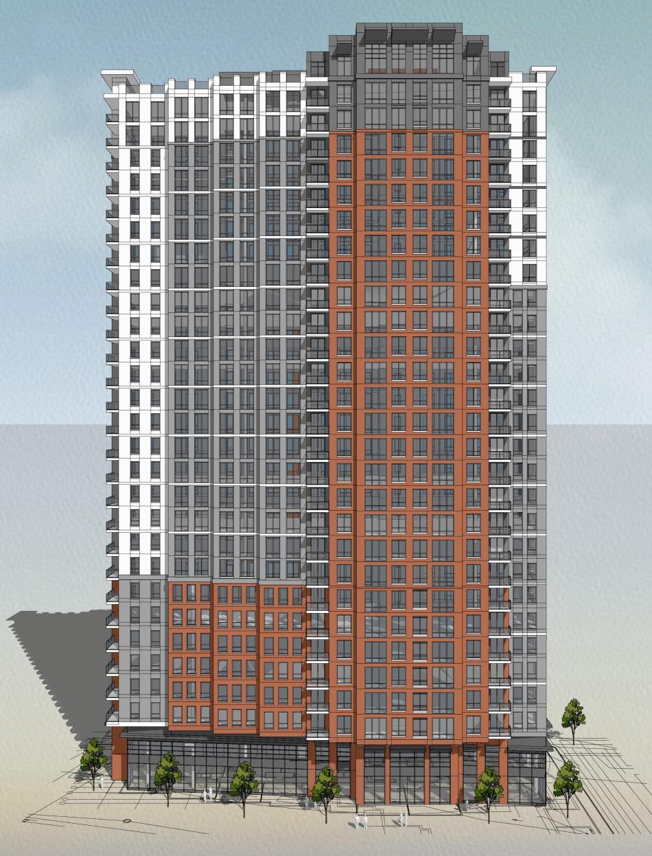](https://atlanta.urbanize.city/sites/default/files/styles/1140w/public/2024-09/Underground%20Tower%20rendering.jpg?itok=WTsaO_Hg "Designs, Niles Bolton Associates; courtesy of Underground Atlanta. ") Designs, Niles Bolton Associates; courtesy of Underground Atlanta. **...** ***Follow us on social media:*** [Twitter](https://twitter.com/UrbanizeATL) / [Facebook](https://www.facebook.com/UrbanizeATL)/**and now:** [Instagram](https://www.instagram.com/urbanizeatlanta_/) • [Downtown news, discussion](https://atlanta.urbanize.city/neighborhood/downtown-0) (Urbanize Atlanta) Tags [76 Wall St.](https://atlanta.urbanize.city/tags/76-wall-st) [Underground Atlanta](https://atlanta.urbanize.city/tags/underground-atlanta) [Transit](https://atlanta.urbanize.city/tags/transit) [Downtown Development](https://atlanta.urbanize.city/tags/downtown-development-0) [(42348)](https://atlanta.urbanize.city/tags/42348) [Lalani Ventures](https://atlanta.urbanize.city/tags/lalani-ventures) [Exact Capital](https://atlanta.urbanize.city/tags/exact-capital) [Exact Capital Group](https://atlanta.urbanize.city/tags/exact-capital-group) [Affordable Housing](https://atlanta.urbanize.city/tags/affordable-housing-0) [Invest Atlanta](https://atlanta.urbanize.city/tags/invest-atlanta) [Dallas Austin](https://atlanta.urbanize.city/tags/dallas-austin) [Pigalle by Paris on Ponce](https://atlanta.urbanize.city/tags/pigalle-paris-ponce) [Pigalle](https://atlanta.urbanize.city/tags/pigalle) [MJQ](https://atlanta.urbanize.city/tags/mjq) [MJQ Concourse](https://atlanta.urbanize.city/tags/mjq-concourse) [Niles Bolton Associates](https://atlanta.urbanize.city/tags/niles-bolton-associates) Images [](https://atlanta.urbanize.city/sites/default/files/styles/1140w/public/2024-09/Underground%20Atlanta%20tower%20base.png?itok=O439978J "Designs, Niles Bolton Associates; courtesy of Underground Atlanta. ") Closer look at the 76 Wall St. proposal's base floors. (We've asked for clarification on which cross-streets these are and will relay any details that come.)Designs, Niles Bolton Associates; courtesy of Underground Atlanta. [](https://atlanta.urbanize.city/sites/default/files/styles/1140w/public/2024-09/Underground%20Atlanta%20tower%2076%20Wall%20St.%20map.png?itok=5EVHZ80u "Google Maps ") Planned location of the 30-story Underground Atlanta residential tower, next to main plazas and fountains. Google Maps [](https://atlanta.urbanize.city/sites/default/files/styles/1140w/public/2024-09/Underground%20Atlanta%20tower%2076%20Wall%20St.%20July%202024.png?itok=r6Ar0GZ5 "Google Maps") As seen in July, the 76 Wall St. building where the residential tower is planned at Underground Atlanta's northern edge. Google Maps [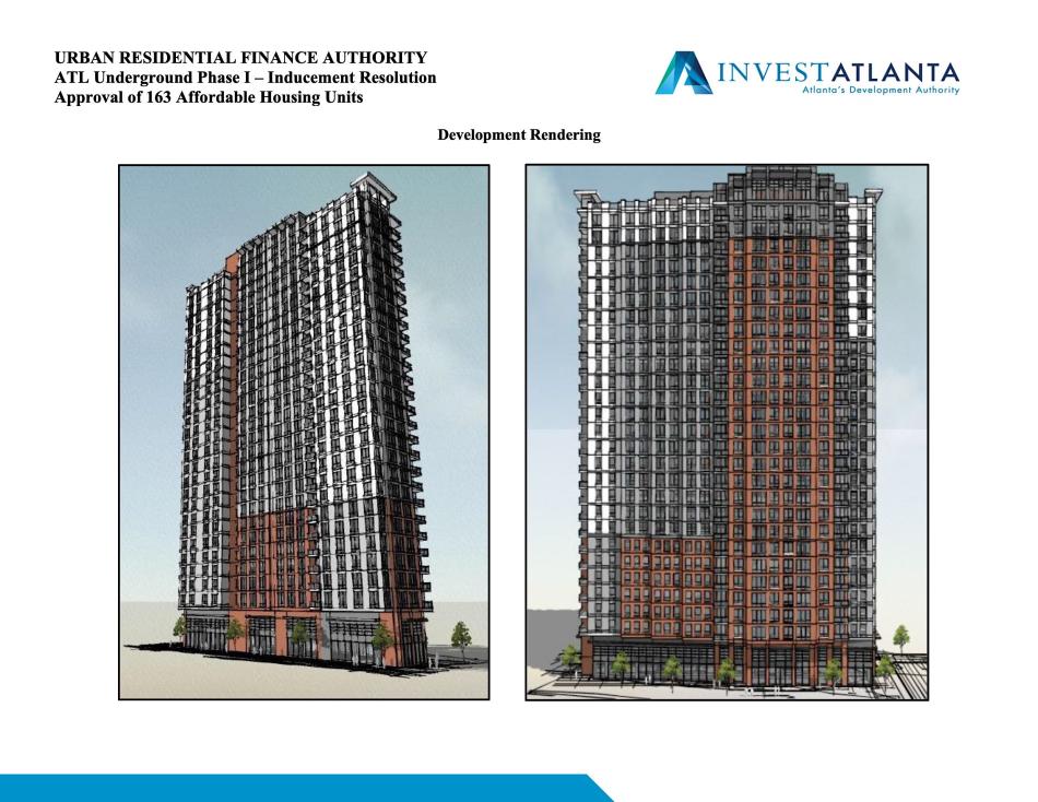](https://atlanta.urbanize.city/sites/default/files/styles/1140w/public/2024-09/Underground%20Atlanta%20tower%2076%20Wall%20St.%201.jpg?itok=8zSl__K- "Invest Atlanta") Invest Atlanta [](https://atlanta.urbanize.city/sites/default/files/styles/1140w/public/2024-09/Underground%20Tower%20rendering.jpg?itok=WTsaO_Hg "Designs, Niles Bolton Associates; courtesy of Underground Atlanta. ") Designs, Niles Bolton Associates; courtesy of Underground Atlanta. Subtitle Now with Invest Atlanta blessing, $160M proposal calls for more than 400 residences, minimal parking Neighborhood [Downtown](https://atlanta.urbanize.city/neighborhood/downtown-0) Background Image Image 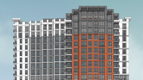 Before/After Images Sponsored Post Off
 atlanta.urbanize.city
30-story tower at Underground Atlanta; Beltline rail update; more! Josh Green Wed, 09/18/2024 - 16:07 **DOWNTOWN**—There’s good news afoot this week for Atlantans who believe the solution to downtown’s ills begins with the addition of more people living there. Underground Atlanta owner Lalani Ventures is partnering with Exact Capital, a New York City-based real estate firm, on plans to build a 30-story mixed-use tower that would lord over the plazas where Atlanta’s famed Peach Drop is traditionally held. As [Bisnow Atlanta](https://www.bisnow.com/atlanta/news/multifamily/underground-atlanta-owner-seeking-city-incentive-for-new-apartment-tower-125926?utm_source=outbound_pub_8&utm_campaign=outbound_issue_80280&utm_content=outbound_link_1&utm_medium=email) reports, Lalani Ventures is asking the city’s economic development arm, Invest Atlanta, for a $40-million incentive to help develop 405 apartments that would climb 30 stories from street level at 76 Wall St., where a one-story retail building stands today. Those residences would include a mix of housing types—student, market-rate, and income-restricted—while other facets of the tower project would see retail, public spaces, and art incubators. [](https://atlanta.urbanize.city/sites/default/files/styles/1140w/public/2024-09/Underground%20Atlanta%20tower%2076%20Wall%20St.%201.jpg?itok=8zSl__K- "Invest Atlanta") Invest Atlanta [](https://atlanta.urbanize.city/sites/default/files/styles/1140w/public/2024-09/Underground%20Atlanta%20tower%2076%20Wall%20St.%20map.png?itok=5EVHZ80u "Google Maps ") Planned location of the 30-story Underground Atlanta residential tower, next to main plazas and fountains. Google Maps Lalani Ventures CEO Shaneel Lalani [told](https://www.bisnow.com/atlanta/news/multifamily/underground-atlanta-owner-seeking-city-incentive-for-new-apartment-tower-125926?utm_source=outbound_pub_8&utm_campaign=outbound_issue_80280&utm_content=outbound_link_1&utm_medium=email) the website the transit-connected project would cost $160 million total, with 163 apartments reserved for renters earning 60 percent of the area median income or less (those rents: $971 for a studio, up to $1,225 for two-bedroom units), equaling a win-win for all involved. Nearby, Lalani is also [planning to convert](https://www.bisnow.com/atlanta/news/multifamily/underground-atlanta-owner-to-convert-downtown-office-tower-to-aparments-120462) two-thirds of the One Park Tower he owns at 34 Peachtree St. into housing. The 30-story building would mark Lalani’s first ground-up new development since purchasing Underground for $31.6 million four years ago. Invest Atlanta’s Urban Residential Finance Authority is scheduled to hear Lalani’s proposal Thursday, and Lalani told Bisnow the search for construction financing will commence once the incentive is approved. Early timelines call for a two-year construction phase with delivery in 2027. [](https://atlanta.urbanize.city/sites/default/files/styles/1140w/public/2024-09/Underground%20Atlanta%20tower%2076%20Wall%20St.%20July%202024.png?itok=r6Ar0GZ5 "Google Maps") As seen in July, the 76 Wall St. building where the residential tower is planned at Underground Atlanta's northern edge. Google Maps **…** **CITYWIDE**—Heads up, ATL transit buffs: Atlanta Beltline officials have scheduled a Citywide Conversation next week to shed light on the ongoing Beltline Transit Study, an [analysis of plans](https://atlanta.urbanize.city/post/beltline-study-nearly-14-miles-transit-around-loop-rail-buses) for nearly 14 miles of mobility possibilities that kicked off a year ago. An announcement for the virtual meeting includes a thought-provoking new rendering of a light-rail vehicle on a grassy lawn track along the Southside Trail near Pittsburgh Yards—or what Beltline rail proponents might call transit porn, and opponents a gross distortion of the truth. [](https://atlanta.urbanize.city/sites/default/files/styles/1140w/public/2024-09/Atlanta%20Beltline%20rail%20near%20Pittsburgh%20Yards%20.jpg?itok=9Ui7-fKv "Atlanta BeltLine Inc. ") Transit-rich future for the Beltline's Southside Trail? Atlanta BeltLine Inc. The meeting is planned from 6:30 to 8 p.m. Sept. 26, with project leaders promising the latest updates on possible transit station locations, preferred routes, equitable transportation solutions, and more. “Your engagement is essential to the success of the study and delivering on its goals and objectives of connectivity, sustainability, equity and inclusion, and future implementation and operations,” reads a meeting announcement. Register for the 90-minute meeting [right here](https://beltline.org/events/66b3d91579d50fb5a55a0004/?id=66b3d91579d50fb5a55a0004&alias=abi). **…** **CITYWIDE**—In relevant government news, the Development Authority of Fulton County—aka, [Develop Fulton](https://www.linkedin.com/company/developfulton/)—has appointed a familiar name to a top leadership position. Former U.S. Congressman Kwanza Hall, also a longtime Atlanta City Council member, was unanimously elected Develop Fulton’s new chairman at a specially called meeting Thursday. Hall previously served as the agency’s vice chairman and will replace outgoing Chairman Georgia Sen. Brandon Beach in the lead role, according to an announcement today. Hall, a Southwest Atlanta native who attended the Massachusetts Institute of Technology, has been “a driving force behind initiatives in economic inclusion, workforce development, urban design, and the arts,” according to Develop Fulton officials. He previously served as the U.S. representative for Georgia’s 5th Congressional District. “Expanding Fulton County’s diverse, resilient, and thriving business community is at the heart of our mission,” said Hall, who will be sworn in as chairman next week, in a prepared statement. “We’re focused on job creation and expanding our tax base with quality development emerging from leading growth industries including logistics, clean tech, biomedical, manufacturing, fintech, and more.” **...** ***Follow us on social media:*** [Twitter](https://twitter.com/UrbanizeATL) / [Facebook](https://www.facebook.com/UrbanizeATL)/**and now:** [Instagram](https://www.instagram.com/urbanizeatlanta_/) • [Poll: Which major downtown ATL project is most exciting, beneficial?](https://atlanta.urbanize.city/post/poll-which-major-downtown-atl-project-most-exciting-beneficial) (Urbanize Atlanta) Tags [ATL News Roundup](https://atlanta.urbanize.city/tags/atl-news-roundup) [Underground Atlanta](https://atlanta.urbanize.city/tags/underground-atlanta) [BeltLine Rail](https://atlanta.urbanize.city/tags/beltline-rail) [BeltLine Rail Now!](https://atlanta.urbanize.city/tags/beltline-rail-now) [Better Atlanta Transit](https://atlanta.urbanize.city/tags/better-atlanta-transit) [Beltline Transit](https://atlanta.urbanize.city/tags/beltline-transit) [Transit](https://atlanta.urbanize.city/tags/transit) [Atlanta BeltLine](https://atlanta.urbanize.city/tags/atlanta-beltline) [Beltline](https://atlanta.urbanize.city/tags/beltline) [Kwanza Hall](https://atlanta.urbanize.city/tags/kwanza-hall) [Fulton County Development Authority](https://atlanta.urbanize.city/tags/fulton-county-development-authority) [Develop Fulton](https://atlanta.urbanize.city/tags/develop-fulton) [Downtown Development](https://atlanta.urbanize.city/tags/downtown-development-0) [(42348)](https://atlanta.urbanize.city/tags/42348) [Fulton County](https://atlanta.urbanize.city/tags/fulton-county) [Pittsburgh Yards](https://atlanta.urbanize.city/tags/pittsburgh-yards) [Bisnow Atlanta](https://atlanta.urbanize.city/tags/bisnow-atlanta) [Bisnow](https://atlanta.urbanize.city/tags/bisnow) [Lalani Ventures](https://atlanta.urbanize.city/tags/lalani-ventures) [Exact Capital](https://atlanta.urbanize.city/tags/exact-capital) [Exact Capital Group](https://atlanta.urbanize.city/tags/exact-capital-group) [Affordable Housing](https://atlanta.urbanize.city/tags/affordable-housing-0) Images [](https://atlanta.urbanize.city/sites/default/files/styles/1140w/public/2024-09/Underground%20Atlanta%20tower%2076%20Wall%20St.%20July%202024.png?itok=r6Ar0GZ5 "Google Maps") As seen in July, the 76 Wall St. building where the residential tower is planned at Underground Atlanta's northern edge. Google Maps [](https://atlanta.urbanize.city/sites/default/files/styles/1140w/public/2024-09/Underground%20Atlanta%20tower%2076%20Wall%20St.%20map.png?itok=5EVHZ80u "Google Maps ") Planned location of the 30-story Underground Atlanta residential tower, next to main plazas and fountains. Google Maps [](https://atlanta.urbanize.city/sites/default/files/styles/1140w/public/2024-09/Underground%20Atlanta%20tower%2076%20Wall%20St.%201.jpg?itok=8zSl__K- "Invest Atlanta") Invest Atlanta [](https://atlanta.urbanize.city/sites/default/files/styles/1140w/public/2024-09/Atlanta%20Beltline%20rail%20near%20Pittsburgh%20Yards%20.jpg?itok=9Ui7-fKv "Atlanta BeltLine Inc. ") Transit-rich future for the Beltline's Southside Trail? Atlanta BeltLine Inc. Subtitle Real estate, architecture, and urban planning news from around Atlanta this week Background Image Image 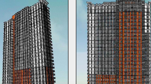 Before/After Images Sponsored Post Off
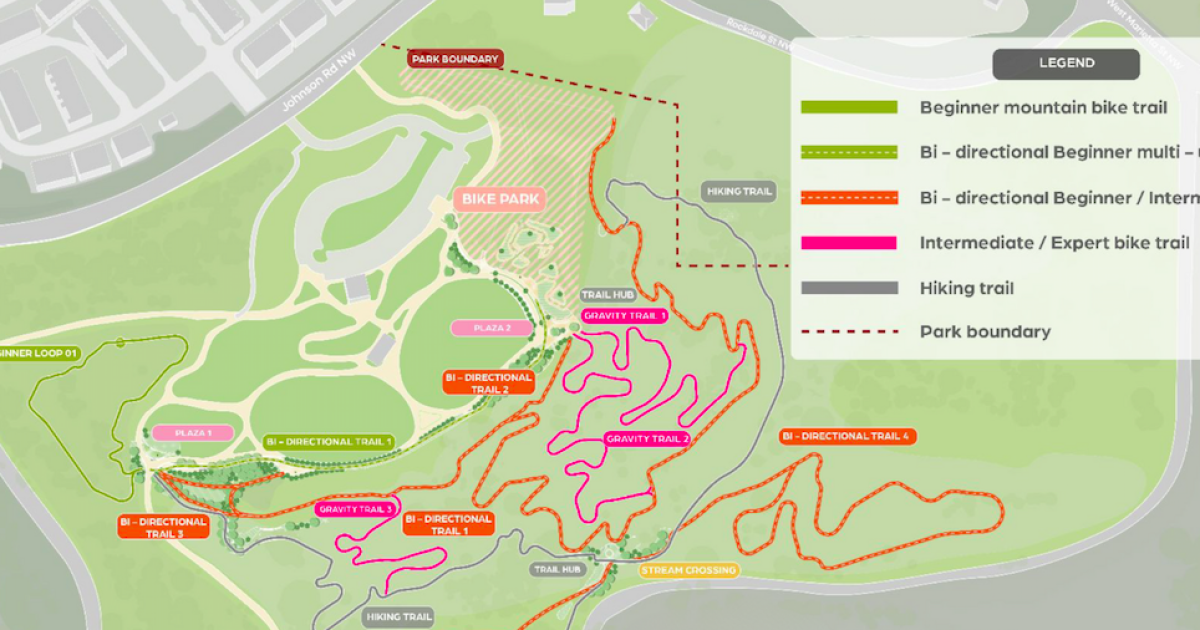 atlanta.urbanize.city
Exclusive: Beltline mountain bike park scores $8M gift, refines plans Josh Green Mon, 09/16/2024 - 13:33 A mountain bike park with connectivity to the Atlanta Beltline that’s being called world-class, remarkably inclusive, and a “game-changer” for the city’s Westside is several million steps closer to happening today, as project leaders exclusively tell Urbanize Atlanta. Atlanta Beltline Partnership has secured an $8 million donation for the Westside Park project from the Chestnut Family Foundation, a charitable organization led by billionaire Mailchimp cofounder and former CEO Ben Chestnut and his wife Teresa. Chestnut, a [noted](https://www.singletracks.com/mtb-trails/mtb-atlanta-receives-1m-grant-for-trail-building-projects/) mountain biking [enthusiast](https://www.instagram.com/p/C_GEIQPuxI4/), stepped down as CEO of Intuit Mailchimp for a business advisory position two years ago, following Intuit’s acquisition of the Atlanta-based e-marketing giant. Atlanta Beltline Partnership leaders are calling the $8 million pledge "transformative" and a significant milestone toward creating “one of the most unique and inclusive biking facilities in Atlanta,” which will offer a new recreation experience like nothing else in the metro today, according to an announcement. The official name of the project is now [Bike Park at Westside Park](https://beltline.org/learn/current-projects/westside-park-mountain-bike-pump-track/?gad_source=1&gclid=Cj0KCQjw5ea1BhC6ARIsAEOG5pw3y-6xYNe1Y_4YG94BpbpearnUch01tgY0V0TKZBtmaW5Hu1gGSXEaAnVoEALw_wcB). [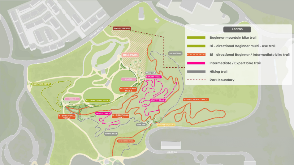](https://atlanta.urbanize.city/sites/default/files/styles/1140w/public/2024-09/Westside%20Park%20Mountain%20Bike%20Trail%20with%20Legend-2024_1920x1080.png?itok=VsJeaOrI "Courtesy of Atlanta Beltline Partnership") An overview of Bike Park at Westside Park with a legend. Courtesy of Atlanta Beltline Partnership The Chestnut Family Foundation partners with nonprofits that strive to improve access and choices for children—and the Chestnuts envision the bike park as an entrée into the world of mountain biking for numerous Atlanta communities. “Westside Park is the perfect place to create new opportunities for residents to explore and enjoy the outdoors,” said Ben Chestnut in a prepared statement, “fostering a love for biking in communities that previously didn’t include unique trails like this.” Beltline designers relayed in a planning meeting in August last year the mountain bike park will be installed across roughly 45 wooded acres at the northeast corner of Westside Park. The 280-acre greenspace—considered the largest in Atlanta—opened its [**first phase**](https://atlanta.urbanize.city/post/24-photos-wandering-atlantas-largest-public-park-now-open) three years ago. The design process has been ongoing throughout the past year, and exactly what the park will offer once fully funded and built has come into sharper focus. The bulk of the project will see 2.25 miles of mountain biking trails that designers say will be catered to all skill levels—all minutes from the urban settings of Midtown and downtown. Those will include beginner and intermediate routes with bridges, boardwalks, natural obstacles, rollers, berms, and switchback trails. For more experienced (and daring) riders, a steeper gravity trail will be designed to challenge, with large rocks, tight switchbacks, technical rock gardens, steep drops, and other natural and built obstacles, according to the partnership. That section will also see more serene hiking trails weaving through the forest at various levels of difficulty. Designs call for protecting the area’s mature tree canopy, minimizing environmental impact, and keeping bikers and hikers separate for safety, Beltline officials have said. Other planned features of the park are described as follows: > > * ***Start area and overlook:*** *The park will feature a dual-purpose start area integrated with an overlook, providing a stunning view of the bike park and surrounding landscape. This area will serve as a starting point for adventures and a spot for relaxation and social interaction.* > * ***Bicycle playground:*** *Tailored for beginners, particularly children, this area will feature low-risk elements such as balance beams, small rollers, and gentle turns to help new riders build confidence and basic bike handling skills.* > * ***Jump lines:*** *A range of jump lines will be available, from beginner-friendly to advanced, featuring clear signage for difficulty levels and safe landing zones to encourage progression and skill development.* > * ***Skills course:*** *This area will present technical challenges such as narrow bridges, rock gardens, and tight switchbacks, designed to simulate real trail conditions and help riders of all levels improve their technical skills.* > * ***Pump track:*** *Available for a variety of wheeled sports, this state-of-the-art asphalt pump track is designed for riders of all skill levels to practice momentum, balance, and agility. The track includes berms and rollers, allowing riders to refine their technique and bike control without pedaling.* > The Atlanta Beltline Partnership has taken on the role of raising money for the bike park, while Atlanta Beltline Inc. will build it. [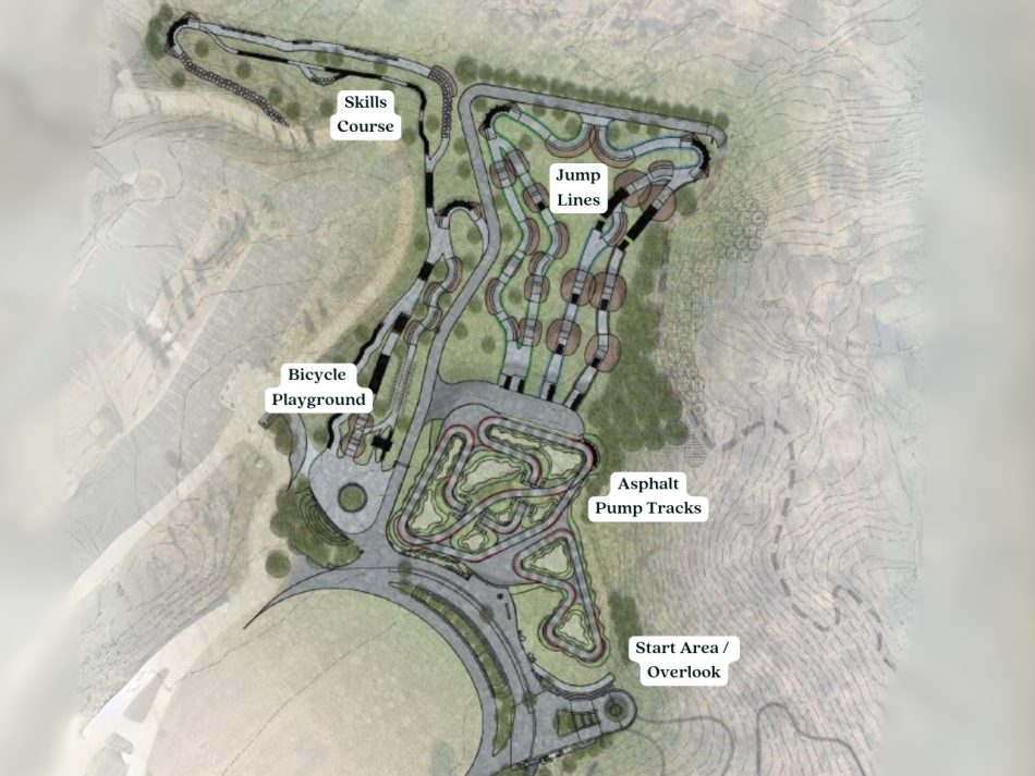](https://atlanta.urbanize.city/sites/default/files/styles/1140w/public/2024-09/Westside%20Park%20Mountain%20Bicycle%20Playground.png?itok=NMsdzi6b "Courtesy of Atlanta Beltline Partnership") Zooming in to plans for the park's bike playground and other sections. Courtesy of Atlanta Beltline Partnership Design work remains in progress now, and according to current schedules, the initial phase of bike park construction is expected to begin at the end of 2025. Exactly how large that first phase will be is contingent on more funding coming in (additional [fundraising measures](https://beltline.org/learn/current-projects/westside-park-mountain-bike-pump-track/) are ongoing). We’ve asked Beltline reps for information on the total project cost of the park as envisioned, and we’ll update this story with any additional details that come. Atlanta Beltline Partnership executive director Rob Brawner said in the announcement an additional $6 million is being sought to “fully bring this ambitious design to life,” and that the Chestnut Family Foundation gift “serves as a powerful call to action for other donors.” MTB Atlanta, the Atlanta Chapter of Southern Off-Road Bicycle Association, is also a partner in the bike park’s development. Brett Davidson, MTB Atlanta executive director, called the Westside Park location ideal “due to its central location, bike connectivity, outstanding amenities, forest canopy, and unique topography,” he said. “This park will serve as a crucial hub for learning, inclusivity in cycling, and passive outdoor recreation right in the heart of the city.” [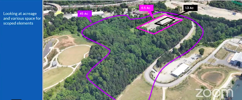](https://atlanta.urbanize.city/sites/default/files/styles/1140w/public/2023-08/2%20Westside%20Park%20Mountain%20biking%20_0.png?itok=UfsYcs1H "Atlanta BeltLine Inc. ") The scope of the Westside Park corner in question, situated between a hilltop greenspace (left) and the park's reservoir. Atlanta BeltLine Inc. For inspiration, Beltline designers have looked to [**Bentonville, Arkansas**](https://www.visitbentonville.com/sp/bike/)—aka, the “Mountain Biking Capital of the World”—where Walmart heirs who are mountain-biking enthusiasts have helped turn the city into something of a mecca for the sport. Beltline president and CEO Clyde Higgs predicted the bike park will be “game-changer” for the Westside and critical component of the Beltline’s overall mission to boost the city's health by way of inclusive recreation opportunities. “It’s not just about physical activity,” said Higgs, “but about creating a community hub that will create a passion for a sport that many people will enjoy for decades.” **...** ***Follow us on social media:*** [Twitter](https://twitter.com/UrbanizeATL) / [Facebook](https://www.facebook.com/UrbanizeATL)/**and now:** [Instagram](https://www.instagram.com/urbanizeatlanta_/) • [Grove Park news, discussion](https://atlanta.urbanize.city/neighborhood/grove-park) (Urbanize Atlanta) Tags [Bike Park at Westside Park](https://atlanta.urbanize.city/tags/bike-park-westside-park) [Westside Park](https://atlanta.urbanize.city/tags/westside-park) [Westside](https://atlanta.urbanize.city/tags/westside-0) [Mountain Biking](https://atlanta.urbanize.city/tags/mountain-biking) [Pump Track](https://atlanta.urbanize.city/tags/pump-track) [Mystery Donors](https://atlanta.urbanize.city/tags/mystery-donors) [Atlanta BeltLine Inc.](https://atlanta.urbanize.city/tags/atlanta-beltline-inc) [Atlanta Mountain Biking](https://atlanta.urbanize.city/tags/atlanta-mountain-biking) [Atlanta Bicycling](https://atlanta.urbanize.city/tags/atlanta-bicycling) [Bicycling](https://atlanta.urbanize.city/tags/bicycling) [Bentonville](https://atlanta.urbanize.city/tags/bentonville) [HGOR](https://atlanta.urbanize.city/tags/hgor) [Sherwood Engineering](https://atlanta.urbanize.city/tags/sherwood-engineering) [Ben Chestnut](https://atlanta.urbanize.city/tags/ben-chestnut) [Chestnut Family Foundation](https://atlanta.urbanize.city/tags/chestnut-family-foundation) [Atlanta Mountain Bike Park](https://atlanta.urbanize.city/tags/atlanta-mountain-bike-park) [Atlanta Pump Track](https://atlanta.urbanize.city/tags/atlanta-pump-track) [Atlanta BeltLine Partnership](https://atlanta.urbanize.city/tags/atlanta-beltline-partnership) [MTB Atlanta](https://atlanta.urbanize.city/tags/mtb-atlanta) [Parks and Rec](https://atlanta.urbanize.city/tags/parks-and-rec) [Atlanta Parks](https://atlanta.urbanize.city/tags/atlanta-parks) [Parks and Recreation](https://atlanta.urbanize.city/tags/parks-and-recreation) [Southern Off-Road Bicycle Association](https://atlanta.urbanize.city/tags/southern-road-bicycle-association) Images [](https://atlanta.urbanize.city/sites/default/files/styles/1140w/public/2024-09/Westside%20Park%20Mountain%20Bike%20Trail%20with%20Legend-2024_1920x1080.png?itok=VsJeaOrI "Courtesy of Atlanta Beltline Partnership") An overview of Bike Park at Westside Park with a legend. Courtesy of Atlanta Beltline Partnership [](https://atlanta.urbanize.city/sites/default/files/styles/1140w/public/2024-09/Westside%20Park%20Mountain%20Bicycle%20Playground.png?itok=NMsdzi6b "Courtesy of Atlanta Beltline Partnership") Zooming in to plans for the park's bike playground and other sections. Courtesy of Atlanta Beltline Partnership Subtitle With donation from Mailchimp cofounder and former CEO, Westside Park project to break ground next year Neighborhood [Grove Park](https://atlanta.urbanize.city/neighborhood/grove-park) Background Image Image 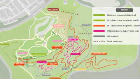 Associated Project [Westside Park](https://atlanta.urbanize.city/project/westside-park) Before/After Images Sponsored Post Off
 atlanta.urbanize.city
In south Decatur, 125 affordable rentals bound for old YMCA site Josh Green Fri, 09/13/2024 - 08:18 On a DeKalb County property where people have worked out and worshipped for decades, an affordable housing initiative is set to move forward as a means of helping lift up households struggling to pay rent in one of America’s [fastest-growing](https://atlanta.urbanize.city/post/new-census-estimate-puts-atlanta-past-washington-dc-philadelphia) cities. Project leaders have scheduled a groundbreaking Saturday morning for a $37-million senior housing venture called Solace Grove on 2nd Avenue in unincorporated Decatur. The corner lot in question, situated where Second Avenue meets Tilson Road, is the site of a former YMCA that’s more recently served as a place of worship. The property is just north of Interstate 20 and a Walmart Supercenter, about two miles directly south of East Lake Golf Club. Solace Grove plans call for 125 new affordable housing options total, plus greenspace, walking paths, and raised-bed gardens. [](https://atlanta.urbanize.city/sites/default/files/styles/1140w/public/2024-09/full%20Solace%20Grove.png?itok=er685WnM "Courtesy of Vecino Group") Plans for parking and Solace Grove's three-story main building, as shown in the lone available rendering. Courtesy of Vecino Group [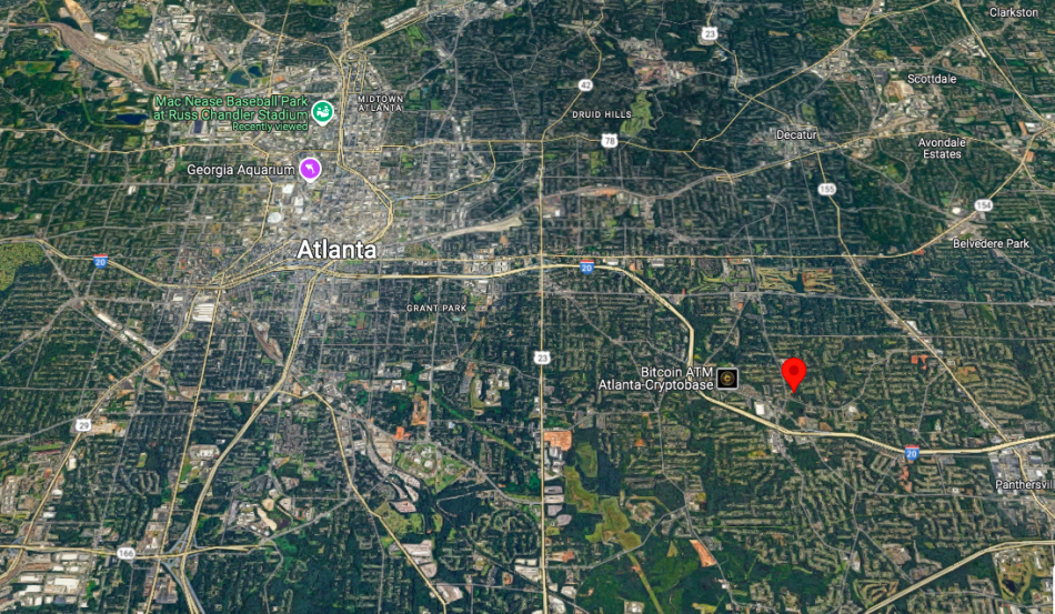](https://atlanta.urbanize.city/sites/default/files/styles/1140w/public/2024-09/Solace%20Grove%20map.png?itok=pB2O0zA6 "Google Maps") The 2318 2nd Ave. location in unincorporated Decatur, southeast of Atlanta.Google Maps The main structure will be a three-story new building with 89 apartments, plus amenities that include a fitness area, community room, computer room, and spaces for arts and crafts. Elsewhere on site, six single-story triplexes with six units each are in the works. All rentals will have either one or two bedrooms. The development team includes Missouri-based national developer Vecino Group, healthcare and wellbeing partner UnitedHealth Group, and community partners Gresham Park CDC and First Baptist Church Gresham Road. All of Solace Grove’s 125 units will be reserved for seniors (ages 62 and older) whose income is at or below 60 percent of the area median income, according to project officials. Funding the project is a $15 million investment via Low-Income Housing Investment Tax Credits from UnitedHealth Group, plus other tax credit support from the Georgia Department of Community Affairs and Dekalb County, per its leadership. [](https://atlanta.urbanize.city/sites/default/files/styles/1140w/public/2024-09/Solace%20Grove%20site%202022.png?itok=gn8GCFU3 "Google Maps") Former YMCA on the 2nd Avenue site in question, at right, in 2022. Google Maps Elsewhere in metro Atlanta, Vecino Group’s recent projects have included an affordable housing [complex](https://atlanta.urbanize.city/post/rapper-ti-affordable-housing-project-bankhead-images) in Grove Park built in partnership with Atlanta rapper T.I., along with the $24-million renovation of the [Aya Tower](https://atlanta.urbanize.city/post/east-point-affordable-housing-aya-vacant-towers-conversion-transit-now-open), a formerly vacant nine-story building near East Point’s MARTA transit station. According to company officials, the developer has built more than 3,000 units of affordable housing to date—including 600 units of permanent supportive housing—across a dozen states. **...** ***Follow us on social media:*** [Twitter](https://twitter.com/UrbanizeATL) / [Facebook](https://www.facebook.com/UrbanizeATL)/**and now:** [Instagram](https://www.instagram.com/urbanizeatlanta_/) • [Decatur news, discussion](https://atlanta.urbanize.city/neighborhood/decatur) (Urbanize Atlanta) Tags [2318 2nd Avenue](https://atlanta.urbanize.city/tags/2318-2nd-avenue) [Solace Grove](https://atlanta.urbanize.city/tags/solace-grove) [senior housing](https://atlanta.urbanize.city/tags/senior-housing) [Affordable Housing](https://atlanta.urbanize.city/tags/affordable-housing-0) [Vecino Group](https://atlanta.urbanize.city/tags/vecino-group) [Gresham Park CDC](https://atlanta.urbanize.city/tags/gresham-park-cdc) [First Baptist Church Gresham Road](https://atlanta.urbanize.city/tags/first-baptist-church-gresham-road) [Gresham Road](https://atlanta.urbanize.city/tags/gresham-road) [Decatur](https://atlanta.urbanize.city/tags/decatur) [Eastside](https://atlanta.urbanize.city/tags/eastside-0) [Atlanta Churches](https://atlanta.urbanize.city/tags/atlanta-churches) [Low-Income Housing Investment Tax Credits](https://atlanta.urbanize.city/tags/low-income-housing-investment-tax-credits) [UnitedHealth Group](https://atlanta.urbanize.city/tags/unitedhealth-group) [Georgia Department of Community Affairs](https://atlanta.urbanize.city/tags/georgia-department-community-affairs) [DeKalb County](https://atlanta.urbanize.city/tags/dekalb-county) [Gresham Park](https://atlanta.urbanize.city/tags/gresham-park) Images [](https://atlanta.urbanize.city/sites/default/files/styles/1140w/public/2024-09/Solace%20Grove%20map.png?itok=pB2O0zA6 "Google Maps") The 2318 2nd Ave. location in unincorporated Decatur, southeast of Atlanta.Google Maps [](https://atlanta.urbanize.city/sites/default/files/styles/1140w/public/2024-09/full%20Solace%20Grove.png?itok=er685WnM "Courtesy of Vecino Group") Plans for parking and Solace Grove's three-story main building, as shown in the lone available rendering. Courtesy of Vecino Group [](https://atlanta.urbanize.city/sites/default/files/styles/1140w/public/2024-09/Solace%20Grove%20site%202022.png?itok=gn8GCFU3 "Google Maps") Former YMCA on the 2nd Avenue site in question, at right, in 2022. Google Maps Subtitle $37M Solace Grove senior complex to include greenspace, trails Neighborhood [DeKalb County](https://atlanta.urbanize.city/neighborhood/dekalb-county) Background Image Image 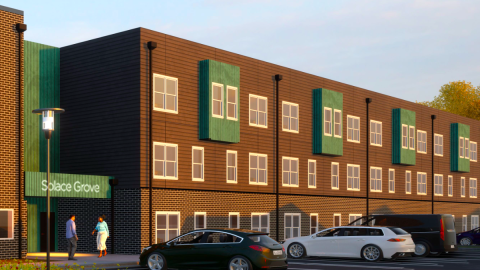 Before/After Images Sponsored Post Off
 atlanta.urbanize.city
Study: Atlanta national leader in return-to-office growth. Really? Josh Green Thu, 09/12/2024 - 13:39 Does it seem like your neighbors and *their* neighbors and the cousins of all those neighbors now work from home at least part of the week? In Atlanta’s case, looks might be deceiving, according to a new analysis of top U.S. office markets. Office foot traffic has remained near post-pandemic highs in major markets during the final weeks of summer, and Atlanta is leading the charge in terms of year-over-year office visit growth among the largest cities in the country, according to location analytics company Placer.ai. Since August 2023, visits to offices in Atlanta (with some suburban job centers included) have grown by 7.3 percent. If that number seems unimpressive, consider that nationwide the growth was just 1.8 percent over the same time period, according to the [Placer.ai Office Index: August 2024 Recap.](https://www.placer.ai/blog/placer-ai-office-index-august-2024-recap) Why so? Analysts noted that major Atlanta employers including UPS and the Centers for Disease Control and Prevention have helped the city’s ranking by enforcing stricter in-office policies in 2024, four years after pandemic lockdowns and the WFH zeitgeist took hold. Another factor, as analysts noted, is several large deals that led to [a surge](https://www.bisnow.com/atlanta/news/office/atlanta-office-market-sees-surge-in-activity-but-vacancy-keeps-rising-123642#:~:text=There%20were%202.4M%20SF,from%2027.7%25%20a%20year%20earlier) in office leasing activity in the early months of 2024; those leases totaled 2.4 million square feet in metro Atlanta—or 71 percent more than the first quarter of 2023. Overall, Atlanta’s office visits in August were nearly 76 percent of what they were in August 2019—good for third place among 11 cities studied. Only Miami and New York, respectively, have seen stronger return-to-office numbers. [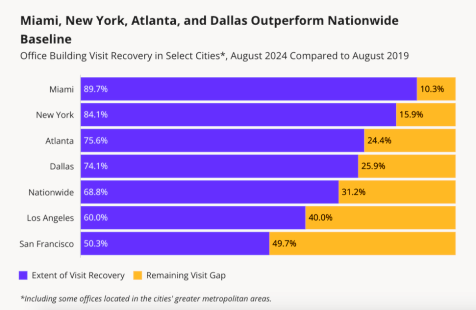](https://atlanta.urbanize.city/sites/default/files/styles/1140w/public/2024-09/Placer.ai%20return%20to%20office%20August%202024%202.png?itok=28OPMpb9 "Placer.ai Office Index: August 2024") Placer.ai Office Index: August 2024 Of course, the outlook isn’t entirely rosy. Office visits nationwide remain down more than 31 percent over what they were five years ago, per Placer.ai data. According to [Colliers](https://www.colliers.com/en/research/atlanta/2024-q2-atlanta-office-market-report), many office occupiers in Atlanta continue to give back space, leading to six consecutive quarters of negative net absorption in the market, with the overall vacancy rate ending the second quarter of 2024 at a new high of 20 percent. Placer.ai analyzed major markets spread across the country—Miami, New York City, Atlanta, Dallas, Washington D.C., Boston, Chicago, Denver, Los Angeles, Houston, and San Francisco—and included foot traffic data at roughly 1,000 office buildings. (Mixed-use buildings with both commercial and residential uses were excluded, for obvious reasons.) [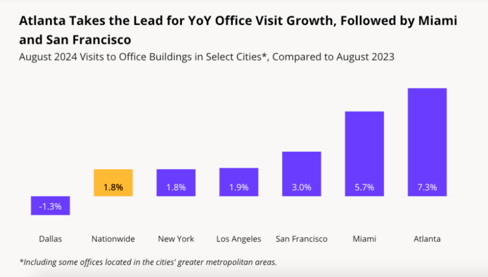](https://atlanta.urbanize.city/sites/default/files/styles/1140w/public/2024-09/Placer.ai%20return%20to%20office%20August%202024%201.png?itok=MoJNjG_b "Placer.ai Office Index: August 2024") Placer.ai Office Index: August 2024 In terms of *who* is heading back to offices, the data point to a dip in the number of households with children with RTO schedules, as flexibility remains at a premium for those groups. Conversely, the share of one-person households and young professionals returning to offices has spiked. “Whether driven by a desire to embrace in-office career growth and mentorship opportunities,” notes the Placer.ai recap, “or by a craving for more social interaction, these employees are returning to the office in ever greater numbers.” **...** ***Follow us on social media:*** [Twitter](https://twitter.com/UrbanizeATL) / [Facebook](https://www.facebook.com/UrbanizeATL)/**and now:** [Instagram](https://www.instagram.com/urbanizeatlanta_/) • [Atlanta declared No. 2 most livable city in U.S. for 2024](https://atlanta.urbanize.city/post/atl-declared-no-2-most-livable-city-us-2024) (Urbanize Atlanta) Tags [Placer.ai Office Index](https://atlanta.urbanize.city/tags/placerai-office-index) [Placer.ai](https://atlanta.urbanize.city/tags/placerai) [Market Studies](https://atlanta.urbanize.city/tags/market-studies) [Urban Studies](https://atlanta.urbanize.city/tags/urban-studies) [Atlanta Trends](https://atlanta.urbanize.city/tags/atlanta-trends) [Office Trends](https://atlanta.urbanize.city/tags/office-trends) [Trends](https://atlanta.urbanize.city/tags/trends) [Atlanta Studies](https://atlanta.urbanize.city/tags/atlanta-studies) [Office Space](https://atlanta.urbanize.city/tags/office-space-0) [Atlanta Office Market](https://atlanta.urbanize.city/tags/atlanta-office-market) [Atlanta Office Space](https://atlanta.urbanize.city/tags/atlanta-office-space) [Market Analysis](https://atlanta.urbanize.city/tags/market-analysis) [Colliers](https://atlanta.urbanize.city/tags/colliers) Images [](https://atlanta.urbanize.city/sites/default/files/styles/1140w/public/2024-09/Placer.ai%20return%20to%20office%20August%202024%202.png?itok=28OPMpb9 "Placer.ai Office Index: August 2024") Placer.ai Office Index: August 2024 [](https://atlanta.urbanize.city/sites/default/files/styles/1140w/public/2024-09/Placer.ai%20return%20to%20office%20August%202024%201.png?itok=MoJNjG_b "Placer.ai Office Index: August 2024") Placer.ai Office Index: August 2024 Subtitle Georgia’s capital led year-over-year analysis as office visit levels edge back toward 2019 numbers Neighborhood [Citywide](https://atlanta.urbanize.city/neighborhood/citywide) Background Image Image 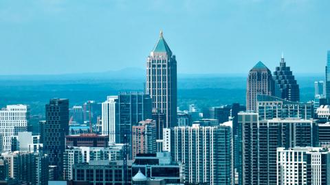 Before/After Images Sponsored Post Off
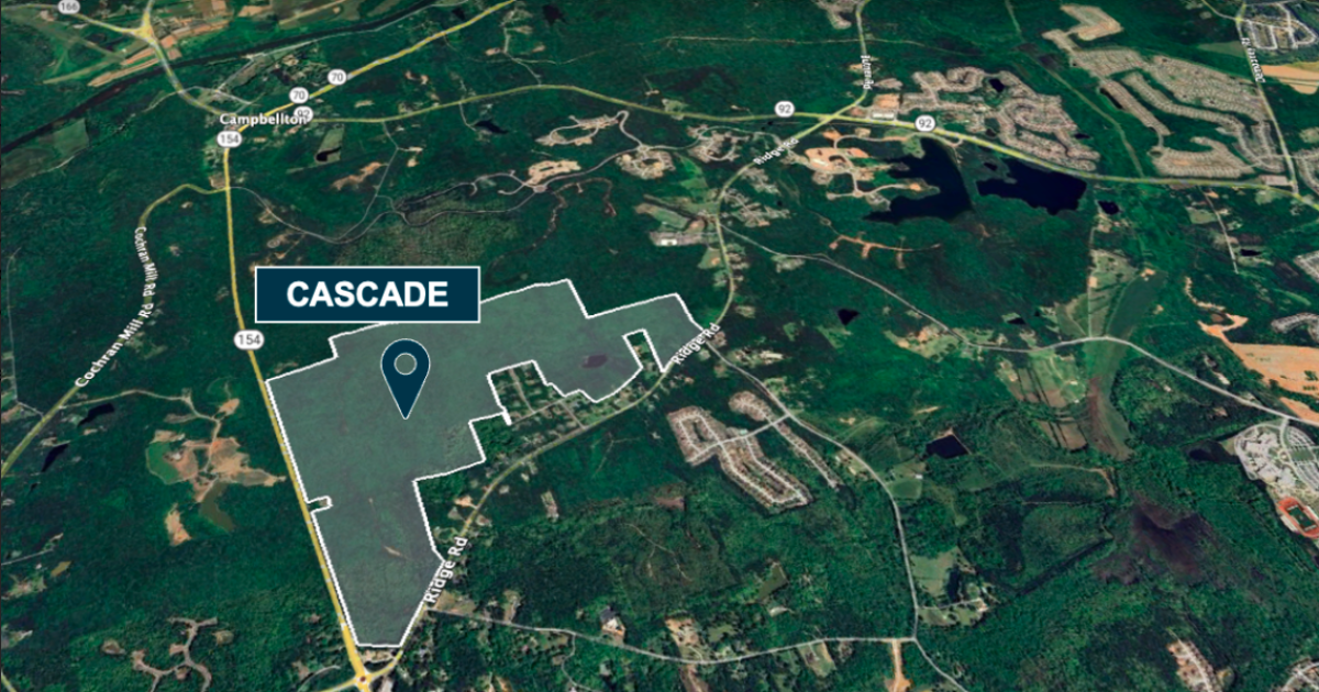 atlanta.urbanize.city
Developer: Southwest of Atlanta, 600-home 'Cascade' is coming Josh Green Wed, 09/11/2024 - 15:17 Another large-scale example of [developer optimism](https://atlanta.urbanize.city/neighborhood/south-fulton) for new communities and open land on the southwest side of metro Atlanta has come to light. Walton Global, an Arizona-based developer and land asset manager with a huge international portfolio, has acquired 327 acres near the southwestern tip of Fulton County to build hundreds of homes near job centers and other draws in the area, per company officials. The project, dubbed “Cascade,” will eventually see roughly 600 residences built across multiple phases where Ridge Road meets Cascade Palmetto Highway (also known as Ga. Highway 154). The site is located northeast of Serenbe, near Cochran Mill Park. The City of South Fulton’s Fire Station No. 8 stands adjacent to one corner of the site. [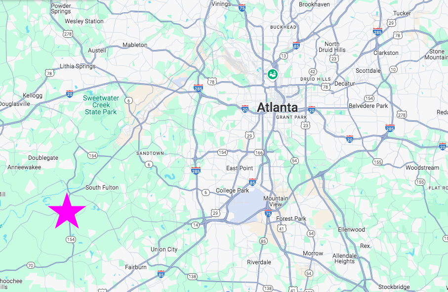](https://atlanta.urbanize.city/sites/default/files/styles/1140w/public/2024-09/Screen%20Shot%202024Cascade%20Cascade%20Walton%20Global%20Cascade%20Palmetto%20Highway%20map.png?itok=8-LvhsRS "Google Maps") Proximity of the Fulton County site in relation to Atlanta and the city's airport, located directly east. Google Maps According to Walton Global officials, selling points for the location include less than 30-minute commutes to downtown Atlanta and Hartsfield-Jackson Atlanta International Airport. Proximity to West Fulton Commerce Park and other employment centers, plus shopping centers, transportation hubs, healthcare facilities, and education centers near Cascade Palmetto Highway are additional perks, per the company. The real estate play aims to meet demand for housing in Atlanta’s suburbs and reflects Walton Global’s broader strategy to invest in places primed development and growth, according to project leaders. “As we continue to expand our portfolio, we’re excited about the Cascade project as it embodies our commitment to quality and sustainability,” Shane Doherty, Walton Global’s senior vice president, said in a project announcement. “We’re dedicated to ensuring the project is seamlessly integrated into the local landscape and provides a boost to the housing market.” We’ve asked project reps for Cascade renderings and other details, and we’ll update this story with any additional information that comes. [](https://atlanta.urbanize.city/sites/default/files/styles/1140w/public/2024-09/Cascade%20Walton%20Global%20Cascade%20Palmetto%20Highway%20.png?itok=zg4oAzm2 "Courtesy of Walton Global ") Scope of the Cascade project across 327 acres along Cascade Palmetto Highway. Courtesy of Walton Global Walton Global bills itself as a leading global real estate investment and land asset management firm with more than 90,000 acres in its portfolio across the U.S. and Canada, valued at more than $4.3 billion. Elsewhere in metro Atlanta, the company has acquired massive tracts of land in recent years for a project called [Pinehills Trail](https://atlanta.urbanize.city/post/arizona-developer-plans-massive-subdivision-northwest-atlanta) in Paulding County (later sold) and another 1,000-home development called [Adamson](https://atlanta.urbanize.city/post/sprawl-massive-swath-land-sells-1000-more-homes-subdivision) near Peachtree City. **...** ***Follow us on social media:*** [Twitter](https://twitter.com/UrbanizeATL) / [Facebook](https://www.facebook.com/UrbanizeATL)/**and now:** [Instagram](https://www.instagram.com/urbanizeatlanta_/) • [South Fulton news, discussion](https://atlanta.urbanize.city/neighborhood/south-fulton) (Urbanize Atlanta) Tags [Ridge Road at Cascade](https://atlanta.urbanize.city/tags/ridge-road-cascade) [Fulton County](https://atlanta.urbanize.city/tags/fulton-county) [Walton Global](https://atlanta.urbanize.city/tags/walton-global) [OTP](https://atlanta.urbanize.city/tags/otp) [Major Developments](https://atlanta.urbanize.city/tags/major-developments) [Cascade Palmetto Highway](https://atlanta.urbanize.city/tags/cascade-palmetto-highway) [Ridge Road](https://atlanta.urbanize.city/tags/ridge-road) [Ga. Highway 154](https://atlanta.urbanize.city/tags/ga-highway-154) Images [](https://atlanta.urbanize.city/sites/default/files/styles/1140w/public/2024-09/Screen%20Shot%202024Cascade%20Cascade%20Walton%20Global%20Cascade%20Palmetto%20Highway%20map.png?itok=8-LvhsRS "Google Maps") Proximity of the Fulton County site in relation to Atlanta and the city's airport, located directly east. Google Maps [](https://atlanta.urbanize.city/sites/default/files/styles/1140w/public/2024-09/Cascade%20Walton%20Global%20Cascade%20Palmetto%20Highway%20.png?itok=zg4oAzm2 "Courtesy of Walton Global ") Scope of the Cascade project across 327 acres along Cascade Palmetto Highway. Courtesy of Walton Global Subtitle Walton Global has purchased more than 300 acres in Fulton County to meet housing demand Neighborhood [South Fulton](https://atlanta.urbanize.city/neighborhood/south-fulton) Background Image Image 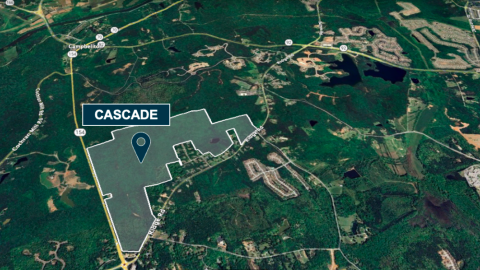 Before/After Images Sponsored Post Off
 atlanta.urbanize.city
Large shelter expansion is full speed ahead near Georgia Aquarium Josh Green Wed, 09/11/2024 - 08:08 Construction is barreling ahead on another downtown project aiming to take in Atlanta’s most vulnerable populations from the streets and help get them on tracks to more sustainable lives. Like the city’s first rapid temporary housing initiative [The Melody](https://atlanta.urbanize.city/post/downtown-homeless-housing-melody-initiative-opens-today), and another modular-housing [proposal](https://atlanta.urbanize.city/post/atl-homeless-housing-record-funding-mayor-city-council) in Mechanicsville detailed by Mayor Andre Dickens last week, the Salvation Army has embarked on a major expansion of its longstanding facilities just north of Centennial Olympic Park. It’s called the Center of Hope. A Salvation Army of Metro Atlanta capital campaign, HOPE with Dignity, raised funds to expand the organization’s Red Shield Services homeless shelter at 400 Luckie St. into a more comprehensive, modernized Center of Hope campus. The current facility is cramped and doesn’t have enough space to adequately separate male and female residents, which has prompted safety concerns, according to project [supporters](https://dudleyventures.com/projects/dvci/salvation-army-center-hope-atl). The 46,000-square-foot Center of Hope will stand five stories where Marietta Street meets Mills Street, about a block from the Georgia Aquarium. [](https://atlanta.urbanize.city/sites/default/files/styles/1140w/public/2024-09/Salvation%20Army%20on%20Marietta%20Street.jpg?itok=PRULjJAD "Josh Green/Urbanize Atlanta ") Construction progress on the Salvation Army expansion at the corner of Marietta and Mills streets, as seen Saturday. Josh Green/Urbanize Atlanta According to Invest Atlanta, the project will double the size of the Salvation Army’s current downtown building. It will house the organization’s emergency and transitional living shelter facility, boosting the number of beds from 321 today to 437. Plans call for two floors of dormitory-style housing for male residents, and another two floors of individualized living spaces. Another component will be a Salvation Army Education and Workforce Development Center with a computer lab and six classrooms, plus study and collaboration areas. That center will offer services to residents such as housing solutions, financial education, emergency assistance programs, and other specialized programs designed to support veteran services. (A portion of the new beds will be reserved specifically for military veterans.) [](https://atlanta.urbanize.city/sites/default/files/styles/1140w/public/2023-09/Salvation%20Army%20Center%20of%20Hope%20Luckie%20Street%201.jpg?itok=ZkUqzRXE "Salvation Army/HOPE with Dignity; via Invest Atlanta ") Six-story facade plans where Marietta Street meets Mills Street downtown. Salvation Army/HOPE with Dignity; via Invest Atlanta [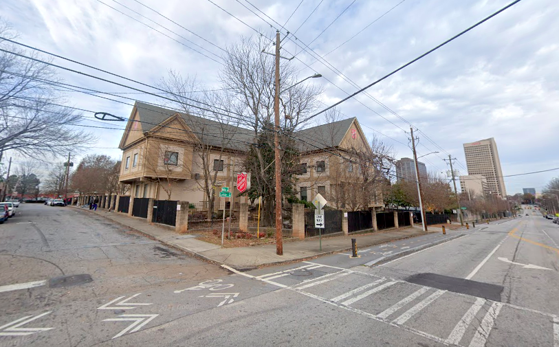](https://atlanta.urbanize.city/sites/default/files/styles/1140w/public/2023-09/Salvation%20Army%20Center%20of%20Hope%20Luckie%20Street%202.png?itok=KOD2kxVg "Google Maps") The Salvation Army's facility at the corner of Luckie and Mills streets today. Google Maps The addition will allow for Salvation Army’s current facilities to be dedicated to women and families, easing concerns caused by overcrowding. Invest Atlanta’s board approved a $2 million Westside Tax Allocation District Ascension Fund Grant to help the project get off the ground last year. Additional funding was sourced from Atlanta Emerging Markets ($15 million), investment firm Dudley Ventures ($9 million), and Truist Community Development Enterprises, ($4 million). According to Dudley Ventures, the expansion project will create 23 full-time jobs in an area with a 47 percent poverty rate—and an unemployment rate of nearly 24 percent. During the intake process, all unemployed residents at the Center of Hope will be connected with the facility’s workforce development center, which will partner with local job placement agencies, per the firm. The Center of Hope is scheduled to be complete next year, according to the Atlanta Downtown Improvement District. [](https://atlanta.urbanize.city/sites/default/files/styles/1140w/public/2023-09/Salvation%20Army%20Center%20of%20Hope%20Luckie%20Street%203.png?itok=gX2ue5oO "Google Maps") The 400 Luckie Street location just north of Centennial Olympic Park. Google Maps **...** ***Follow us on social media:*** [Twitter](https://twitter.com/UrbanizeATL) / [Facebook](https://www.facebook.com/UrbanizeATL)/**and now:** [Instagram](https://www.instagram.com/urbanizeatlanta_/) • [Downtown news, discussion](https://atlanta.urbanize.city/neighborhood/downtown-0) (Urbanize Atlanta) Tags [400 Luckie Street NW](https://atlanta.urbanize.city/tags/400-luckie-street-nw) [Salvation Army Center for Hope](https://atlanta.urbanize.city/tags/salvation-army-center-hope) [Salvation Army](https://atlanta.urbanize.city/tags/salvation-army-1) [Westside Tax Allocation District](https://atlanta.urbanize.city/tags/westside-tax-allocation-district) [Atlanta Development](https://atlanta.urbanize.city/tags/atlanta-development) [Downtown Development](https://atlanta.urbanize.city/tags/downtown-development-0) [Luckie Street](https://atlanta.urbanize.city/tags/luckie-street) [Georgia Aquarium](https://atlanta.urbanize.city/tags/georgia-aquarium) [Atlanta Homeless](https://atlanta.urbanize.city/tags/atlanta-homeless) [California Homeless Housing Needs Assessment](https://atlanta.urbanize.city/tags/california-homeless-housing-needs-assessment) [Homelessness](https://atlanta.urbanize.city/tags/homelessness-0) [Centennial Olympic Park](https://atlanta.urbanize.city/tags/centennial-olympic-park) [Red Shield Services](https://atlanta.urbanize.city/tags/red-shield-services) [Dudley Ventures](https://atlanta.urbanize.city/tags/dudley-ventures) [Salvation Army of Metro Atlanta](https://atlanta.urbanize.city/tags/salvation-army-metro-atlanta) [Atlanta Emerging Markets](https://atlanta.urbanize.city/tags/atlanta-emerging-markets) [Truist Community Development Enterprises](https://atlanta.urbanize.city/tags/truist-community-development-enterprises) [downtown construction](https://atlanta.urbanize.city/tags/downtown-construction) [Center of Hope](https://atlanta.urbanize.city/tags/center-hope) [Salvation Army Center of Hope](https://atlanta.urbanize.city/tags/salvation-army-center-hope-0) Images [](https://atlanta.urbanize.city/sites/default/files/styles/1140w/public/2024-09/Salvation%20Army%20on%20Marietta%20Street.jpg?itok=PRULjJAD "Josh Green/Urbanize Atlanta ") Construction progress on the Salvation Army expansion at the corner of Marietta and Mills streets, as seen Saturday. Josh Green/Urbanize Atlanta [](https://atlanta.urbanize.city/sites/default/files/styles/1140w/public/2023-09/Salvation%20Army%20Center%20of%20Hope%20Luckie%20Street%203.png?itok=gX2ue5oO "Google Maps") The 400 Luckie Street location just north of Centennial Olympic Park. Google Maps [](https://atlanta.urbanize.city/sites/default/files/styles/1140w/public/2023-09/Salvation%20Army%20Center%20of%20Hope%20Luckie%20Street%202.png?itok=KOD2kxVg "Google Maps") The Salvation Army's facility at the corner of Luckie and Mills streets today. Google Maps [](https://atlanta.urbanize.city/sites/default/files/styles/1140w/public/2023-09/Salvation%20Army%20Center%20of%20Hope%20Luckie%20Street%201.jpg?itok=ZkUqzRXE "Salvation Army/HOPE with Dignity; via Invest Atlanta ") Six-story facade plans where Marietta Street meets Mills Street downtown. Salvation Army/HOPE with Dignity; via Invest Atlanta Subtitle Salvation Army project to provide more beds, workforce development center, other support features Neighborhood [Downtown](https://atlanta.urbanize.city/neighborhood/downtown-0) Background Image Image 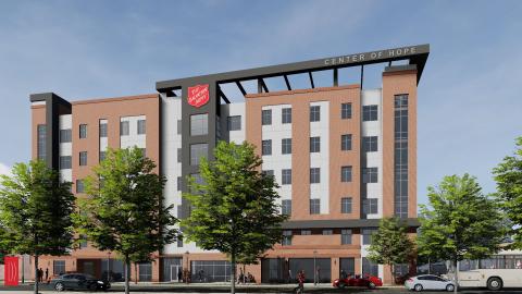 Associated Project [Center of Hope](https://atlanta.urbanize.city/project/center-hope) Before/After Images Sponsored Post Off
 atlanta.urbanize.city
Townhome project in pipeline near popular eastside park Josh Green Mon, 09/09/2024 - 16:08 The trend of building townhomes on vacated or wooded properties in Edgewood and Kirkwood is set to continue along a main thoroughfare for both neighborhoods. According to City of Atlanta Department of City Planning records, a five-unit townhome project is moving forward at the southeast corner of Hosea L. Williams Drive and Montgomery Street. The wooded site is less than a block from Kirkwood’s Coan Park, a popular eastside greenspace for recreation, sports, and events along PATH’s [Eastside Trolley Trail](https://atlanta.urbanize.city/post/eastside-beltline-connection-trolley-trail-construction-progress). Details remain scare, but according to initial filings with the city, plans call for five attached townhomes at the site that would merge five lots into one, near the point where Kirkwood meets Edgewood. [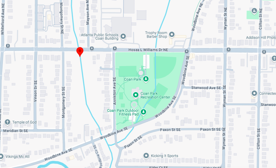](https://atlanta.urbanize.city/sites/default/files/styles/1140w/public/2024-09/1483%20Hosea%20Williams%20Drive%202.png?itok=-nxesrRj "Google Maps") The corner site in question near Coan Park and Kirkwood's westernmost flank. Google Maps Signage posted at the site in August indicates a stream buffer encroachment is involved, regarding a creek that cuts through a portion of the site before heading south toward Memorial Drive. The project would be a relative anomaly for Hosea Williams Drive in the area, an important east-west thoroughfare that’s mostly lined with single-family homes. In recent years, however, townhomes have cropped up in several [projects](https://atlanta.urbanize.city/post/lafrance-square-new-rentals-edgewood-near-pullman-yards-five-story-two-bedrooms) across more northern blocks of both Kirkwood and Edgewood—especially near Pullman Yards—and also in numerous places along the Memorial Drive corridor. [](https://atlanta.urbanize.city/sites/default/files/styles/1140w/public/2024-09/1483%20Hosea%20Williams%20Drive%201.png?itok=tjnGK7Vj "Google Maps") The five parcels along Hosea Williams Drive in March last year. Google Maps **...** ***Follow us on social media:*** [Twitter](https://twitter.com/UrbanizeATL) / [Facebook](https://www.facebook.com/UrbanizeATL)/**and now:** [Instagram](https://www.instagram.com/urbanizeatlanta_/) • [Edgewood news, discussion](https://atlanta.urbanize.city/neighborhood/edgewood) (Urbanize Atlanta) Tags [1483 Hosea Williams Drive](https://atlanta.urbanize.city/tags/1483-hosea-williams-drive) [Coan Park](https://atlanta.urbanize.city/tags/coan-park) [Atlanta Townhomes](https://atlanta.urbanize.city/tags/atlanta-townhomes) [townhomes](https://atlanta.urbanize.city/tags/townhomes) [Edgewood Townhomes](https://atlanta.urbanize.city/tags/edgewood-townhomes) [Kirkwood](https://atlanta.urbanize.city/tags/kirkwood) [Eastside Trolley Trail](https://atlanta.urbanize.city/tags/eastside-trolley-trail) [Edgewood](https://atlanta.urbanize.city/tags/edgewood) [Kirkwood Townhomes](https://atlanta.urbanize.city/tags/kirkwood-townhomes) Images [](https://atlanta.urbanize.city/sites/default/files/styles/1140w/public/2024-09/1483%20Hosea%20Williams%20Drive%202.png?itok=-nxesrRj "Google Maps") The corner site in question near Coan Park and Kirkwood's westernmost flank. Google Maps [](https://atlanta.urbanize.city/sites/default/files/styles/1140w/public/2024-09/1483%20Hosea%20Williams%20Drive%201.png?itok=tjnGK7Vj "Google Maps") The five parcels along Hosea Williams Drive in March last year. Google Maps Subtitle Proposal calls for developing wooded corner where Kirkwood meets Edgewood Neighborhood [Kirkwood](https://atlanta.urbanize.city/neighborhood/kirkwood) Background Image Image  Before/After Images Sponsored Post Off